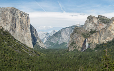
Stories & Guides About the USA - Page 5

Map of the United States highlighting state borders and neighboring connections

States With Most Neighboring Borders

Some US states are geographic connectors, sharing borders with numerous neighbors that facilitate commerce, culture, and transportation. From Tennessee and Missouri's impressive eight borders to island states with none, these connections shape regional dynamics in fascinating ways.

Historic photograph of the Golden Spike ceremony at Promontory Summit, Utah, 1869

The Railroad That United America

In 1869, the driving of a golden spike at Promontory Summit, Utah marked the completion of one of America's greatest engineering marvels - the Transcontinental Railroad. This remarkable feat of 19th century innovation slashed cross-country travel time from months to days, fueled explosive economic growth, and forever transformed how Americans understood their vast nation.

Aerial view of Washington D.C. showing the Capitol Building, National Mall, and surrounding monuments

Why D.C. Became the U.S. Capital

The story of how a swampy plot of land along the Potomac River became America's seat of power involves political deals, geographic compromises, and the vision of the nation's founding fathers.

Towering Louisiana State Capitol building in Baton Rouge with its distinctive art deco design

America's Tallest State Capitols

State capitol buildings stand as proud symbols of governance and architectural achievement across America. From Louisiana's towering skyscraper design to Nebraska's impressive dome, these structures not only house state governments but also showcase remarkable engineering and historical significance.

Downtown Phoenix skyline with heat waves visible over the desert landscape

America's 10 Hottest Summer Cities

When summer arrives in America, certain cities transform into veritable heat islands where temperatures regularly soar well above 100°F. From the desert metropolis of Phoenix to the humid heat of New Orleans, these urban centers present unique challenges to residents and fascinating extremes for weather enthusiasts.

Aerial view of Hawaii's Big Island showing volcanic landscape and coastline

America's 10 Largest Islands

The United States possesses some of the world's most diverse and spectacular islands, from the volcanic landscapes of Hawaii to the arctic wilderness of Alaska. These massive land masses not only contribute significantly to America's geography but also showcase unique ecosystems, cultures, and histories that set them apart from the mainland.

Damaged buildings and cracked roads following a major earthquake in California

America's 10 Shakiest States by Earthquake Risk

While earthquakes can technically occur anywhere, certain states experience significantly more seismic activity than others. From California's infamous San Andreas Fault to lesser-known hotspots in Alaska and Hawaii, these states face constant threats from earth-shaking events that shape both their landscapes and disaster preparedness approaches.

Stack of popular personal finance books including Rich Dad Poor Dad and The Total Money Makeover

12 Best Money Books for Beginners

Getting your financial life in order doesn't require an economics degree. These accessible personal finance books provide a solid foundation for anyone looking to understand money management, debt reduction, investing basics, and building wealth from scratch.

Pittsburgh skyline featuring multiple bridges crossing three rivers with downtown buildings in background

Pittsburgh: City of 446+ Bridges

With more bridges than Venice, Italy, Pittsburgh boasts over 446 bridges spanning its three rivers. The city's unique geography at the confluence of the Allegheny, Monongahela, and Ohio rivers created the need for these numerous crossings, earning Pittsburgh its nickname as America's 'City of Bridges.'

Aerial view of Lake Pontchartrain Causeway extending across water

15 Record-Breaking American Bridges

America's longest bridges represent remarkable feats of engineering that connect communities across vast bodies of water and challenging terrain. These structures not only serve practical transportation needs but also stand as monuments to human ingenuity and determination.

United States Electoral College map with red and blue states

The Electoral College Simplified

The Electoral College is the system the United States uses to elect its president, not through direct popular vote but through a group of electors who cast votes based on their state's election results. This system has decided American presidents for over 200 years, sometimes producing winners who lost the popular vote.

Aerial view of the massive Hoover Dam spanning the Colorado River between Nevada and Arizona

Hoover Dam: How It Remade the Southwest

The Hoover Dam stands as one of America's greatest engineering achievements, transforming the wild Colorado River into a controlled water source that enabled unprecedented growth across the Southwest. From Las Vegas's glittering expansion to California's agricultural empire, the dam's impact extends far beyond its concrete walls.

Hikers on a mountain trail in Colorado's Rocky Mountains with scenic panoramic views

Top 10 Adventure States

America's diverse landscapes offer endless possibilities for outdoor enthusiasts. From scaling mountains in Colorado to kayaking Alaska's glacial waters, these states stand out as premier destinations for adventure seekers looking to connect with nature's most spectacular environments.

The United States Senate chamber with empty seats and the American flag

Small States' Senate Advantage

America's founding fathers established a Senate that gives equal representation to all states regardless of population. This unique feature creates a political landscape where less populous states like Wyoming and Vermont exercise influence far beyond their population size.

Lake Chargoggagoggmanchauggagoggchaubunagungamaugg sign with its 45-letter name in Webster, Massachusetts

America's 45-Letter Record-Breaking Place Name

In the small town of Webster, Massachusetts lies a lake with an extraordinary claim to fame: a 45-letter name that's recognized as the longest place name in the United States. Lake Chargoggagoggmanchauggagoggchaubunagungamaugg has become both a source of local pride and a nationwide curiosity.

Painting of covered wagons traveling along the Oregon Trail with pioneers

Oregon Trail: America's Epic Westward Journey

The Oregon Trail, stretching nearly 2,000 miles from Missouri to Oregon, became the pathway for America's dramatic westward expansion in the mid-1800s. Over 400,000 settlers braved dangerous river crossings, harsh weather, disease, and rugged terrain in search of new opportunities and land in the West, forever changing the nation's landscape and destiny.

The White House with American flag flying prominently in front

10 Most Powerful American Presidents

Throughout American history, certain presidents have wielded extraordinary influence, fundamentally reshaping the office and the nation. From Washington's precedent-setting tenure to FDR's unprecedented four terms, these leaders expanded presidential authority during critical moments and left lasting legacies on American governance.

Historical map showing the original 13 American colonies along the Atlantic coast

13 Colonies to 50 States: America's Territorial Evolution

The United States began as 13 British colonies hugging the Atlantic coastline. Through revolution, purchase, conquest, and compromise, the nation expanded westward and beyond, eventually forming the 50 states we know today. This remarkable transformation spans nearly two centuries and represents one of history's most dramatic national evolutions.

Close-up view of the famous crack in the Liberty Bell at Independence National Historical Park

The Truth About the Liberty Bell's Famous Crack

The Liberty Bell's iconic crack has become a symbol of American resilience and imperfection. But how did this famous fracture actually happen? The answer involves surprising historical twists, debunked myths, and a fascinating journey through early American history.

Map showing California with its 54 electoral votes highlighted

California's Electoral College Dominance Explained

California wields unprecedented influence in presidential elections with its massive 54 electoral votes - more than any other state. This electoral powerhouse status stems from its enormous population, historical growth patterns, and the constitutional framework of American democracy.