America's longest bridges represent remarkable feats of engineering that connect communities across vast bodies of water and challenging terrain. These structures not only serve practical transportation needs but also stand as monuments to human ingenuity and determination.
America's landscape is defined not only by its natural features but also by the impressive infrastructure that connects its distant shores and communities. Among these engineering achievements, the country's longest bridges stand as testaments to human ingenuity, determination, and technological advancement. From the humid bayous of Louisiana to the foggy shores of California, these massive structures have transformed transportation networks while becoming iconic landmarks in their own right.
These bridges represent more than mere connections between points on a map-they're lifelines for commerce, evacuation routes during emergencies, and vital transportation corridors that have reshaped regional economies. Let's explore the most impressive spans that stretch across America's waterways, from record-breaking causeways to architectural marvels that draw visitors from around the world.
Lake Pontchartrain Causeway
The Lake Pontchartrain Causeway holds the distinction of being the longest continuous bridge over water in the United States and was long recognized by Guinness World Records as the longest in the world. Stretching an impressive 23.83 miles (38.35 km) across Lake Pontchartrain in Louisiana, this remarkable structure consists of two parallel bridges that connect Metairie (a suburb of New Orleans) to Mandeville on the North Shore.
Completed in 1956 with a second span added in 1969, the causeway serves as a vital transportation link for approximately 12 million vehicles annually. What makes this bridge particularly unique is the optical illusion it creates-at the midpoint, land disappears completely from view, giving drivers the sensation of heading into an endless horizon. During foggy conditions, navigation becomes so challenging that police escorts are sometimes required.

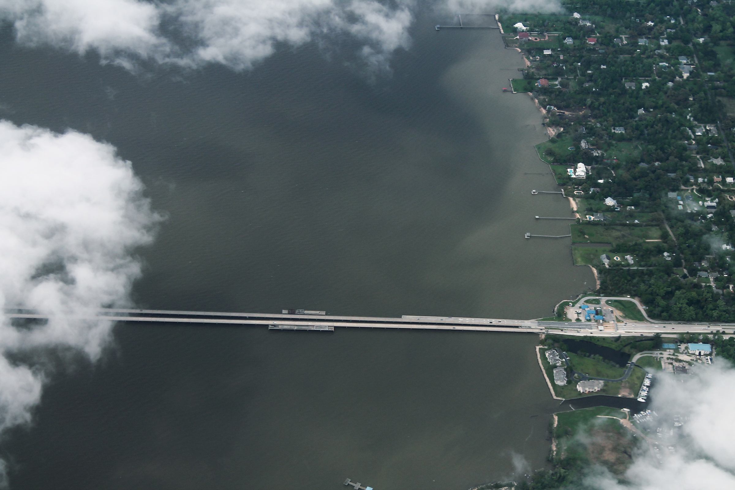
Manchac Swamp Bridge
The Manchac Swamp Bridge carries Interstate 55 through the eerie cypress swamps of Louisiana, spanning 22.8 miles (36.7 km) and earning its place as America's second-longest bridge over water. Completed in 1979, this concrete trestle bridge traverses a section of the LaBranche Wetlands between Ponchatoula and LaPlace.
What sets this bridge apart is the haunting landscape it crosses. Local legend tells of Julia Brown, a supposed voodoo priestess who allegedly cursed the area before her death in 1915. While driving across, passengers can glimpse ancient cypress trees draped with Spanish moss and occasionally spot alligators and other wildlife in the murky waters below.
Atchafalaya Basin Bridge
Also known as the Louisiana Airborne Memorial Bridge, the Atchafalaya Basin Bridge stretches 18.2 miles (29.3 km) across the Atchafalaya Basin, America's largest wetland/swamp. Carrying Interstate 10 between Baton Rouge and Lafayette, this concrete bridge was completed in 1973 at a cost of $114 million ($730 million in today's dollars).
The bridge is actually composed of two parallel structures, each with two lanes, and includes several boat launches for access to the basin. Engineers faced significant challenges during construction due to the swampy terrain. In recent years, the bridge has become notorious for accidents, leading Louisiana to implement strict speed enforcement with hefty fines up to $1,000 for speeders.

Chesapeake Bay Bridge-Tunnel
The Chesapeake Bay Bridge-Tunnel is a 17.6-mile (28.3 km) marvel that combines bridges and tunnels to cross the mouth of Chesapeake Bay, connecting Virginia Beach to the Delmarva Peninsula. Opened in 1964 and expanded in 1999, this engineering wonder was designated as one of the "Seven Engineering Wonders of the Modern World."
What makes this crossing unique is its hybrid design, featuring two one-mile-long tunnels that dip beneath the bay's primary shipping channels, allowing large vessels to pass overhead. The structure includes four artificial islands that serve as transition points between bridges and tunnels. During migration seasons, the bridge-tunnel becomes a popular birdwatching location, as its islands provide resting spots for various bird species.
San Mateo-Hayward Bridge
Spanning the southern part of San Francisco Bay, the San Mateo-Hayward Bridge extends 7 miles (11.3 km) between the Peninsula and the East Bay. Originally opened in 1929 as a narrow two-lane toll bridge, it was completely reconstructed in the 1960s to handle the Bay Area's growing traffic demands.
The bridge features a distinctive design with a high-rise section that provides 135 feet of clearance for shipping traffic. Its western portion consists of a low-level trestle, while the eastern section features the dramatic curved high-rise span. The bridge forms a vital link in the regional transportation network, carrying approximately 93,000 vehicles daily and providing stunning views of the San Francisco Bay.

Seven Mile Bridge
The Seven Mile Bridge is perhaps the most iconic segment of the Overseas Highway (US 1) that connects the Florida Keys. Stretching 6.79 miles (10.9 km) across the open waters between Knight's Key and Little Duck Key, the current structure was completed in 1982, replacing the historic bridge originally built as part of Henry Flagler's Florida East Coast Railway.
The original bridge, completed in 1912, still stands alongside the modern span and has been converted into a fishing pier and pedestrian path called "Old Seven." The modern bridge has become a symbol of the Florida Keys, featuring prominently in numerous films including "True Lies" and "2 Fast 2 Furious." Driving across offers breathtaking 360-degree views of the turquoise waters of the Gulf of Mexico and Atlantic Ocean.
Governor Harry W. Nice Memorial Bridge
The Governor Harry W. Nice Memorial Bridge carries US Route 301 across the Potomac River, connecting Charles County, Maryland, with King George County, Virginia. The original span, opened in 1940, was replaced in 2022 by a new, wider bridge measuring 1.7 miles (2.7 km) in length.
The new bridge features four 12-foot lanes (two in each direction), a significant improvement over the original two-lane structure. It also includes safety shoulders and a bicycle/pedestrian path. The replacement project, which cost approximately $463 million, was necessary to address growing traffic volumes and safety concerns on this vital crossing between Maryland and Virginia.
Verrazano-Narrows Bridge
When it opened in 1964, the Verrazano-Narrows Bridge was the longest suspension bridge in the world. While it has since been surpassed by bridges in other countries, it remains the longest suspension bridge in the Americas, with a main span of 4,260 feet (1,298 m) and a total length of 13,700 feet (4,176 m).
Connecting Brooklyn and Staten Island in New York City, this double-decked giant was designed by Othmar Ammann, who also designed several other iconic New York bridges. The bridge's towers are so tall (693 feet) and far apart that their tops are 1.625 inches (4.1 cm) farther away from each other than their bases due to the curvature of the Earth. The Verrazano-Narrows serves as the starting point for the New York City Marathon and carries approximately 200,000 vehicles daily.

Golden Gate Bridge
Perhaps America's most recognizable bridge, the Golden Gate Bridge spans the Golden Gate Strait, connecting San Francisco to Marin County. Completed in 1937, the bridge extends 8,981 feet (2,737 m) with a main suspension span of 4,200 feet (1,280 m), which was the longest in the world until the completion of the Verrazano-Narrows Bridge.
The bridge's distinctive "International Orange" color was specifically chosen to enhance its visibility in San Francisco's frequent fog while complementing the natural surroundings. Chief engineer Joseph Strauss implemented revolutionary safety measures during construction, including the first-ever use of hard hats and a safety net that saved 19 workers (known as the "Halfway to Hell Club"). Today, the Golden Gate Bridge carries about 112,000 vehicles daily and has become the ultimate symbol of San Francisco and American engineering ingenuity.
Mackinac Bridge
Known affectionately as "Mighty Mac" or "Big Mac," the Mackinac Bridge connects Michigan's Upper and Lower Peninsulas across the Straits of Mackinac. Opened in 1957, this suspension bridge stretches 5 miles (8 km) and ranks as the longest suspension bridge in the western hemisphere between anchorages.
The bridge is designed to withstand extreme weather conditions, with the ability to sway up to 35 feet (10.7 m) in high winds. This flexibility is necessary given its location, where winds can exceed 30 mph for days at a time. Every Labor Day since 1958, the Mackinac Bridge Authority hosts the Mackinac Bridge Walk, allowing pedestrians to cross the normally vehicle-only structure, with approximately 25,000-30,000 people participating annually.

Bay Bridge
The San Francisco-Oakland Bay Bridge, commonly known simply as the Bay Bridge, carries Interstate 80 across San Francisco Bay, connecting the cities of San Francisco and Oakland. This complex structure consists of two sections-a western suspension span and an eastern self-anchored suspension span-connected by Yerba Buena Island in the middle.
The original eastern span was damaged in the 1989 Loma Prieta earthquake, leading to a $6.5 billion replacement project completed in 2013. The new eastern span features a unique single-tower self-anchored suspension design-the world's longest of its type. At night, the western span is illuminated by "The Bay Lights," an LED light sculpture with 25,000 individually programmable white lights that create shifting patterns across the bridge cables.
Astoria-Megler Bridge
The Astoria-Megler Bridge spans the Columbia River between Astoria, Oregon, and Point Ellice, Washington. Stretching 21,474 feet (4.1 miles/6.6 km), it is the longest continuous truss bridge in North America. Completed in 1966, this green-painted steel structure provides a vital transportation link in the Pacific Northwest.
The bridge features a 1,232-foot-long main span that provides 193 feet of clearance for ships navigating the Columbia River. One unique aspect of this bridge is its design, which includes a 2,468-foot cantilever through-truss main channel span connected to a long approach viaduct on the Oregon side. Each September, thousands of participants run across the bridge during the Great Columbia Crossing, the only time pedestrians are allowed on the structure.

New River Gorge Bridge
While not among the longest in overall length, the New River Gorge Bridge in West Virginia deserves mention for its impressive 3,031-foot (924 m) arch span, making it the longest single-span steel arch bridge in the United States and the third-longest in the world. Completed in 1977, the bridge soars 876 feet above the New River.
Before the bridge's construction, crossing the gorge required a winding 40-minute drive down narrow mountain roads. The bridge reduced this journey to less than a minute. Each October, the bridge closes for "Bridge Day," when thousands of spectators watch BASE jumpers leap from the structure in what has become the largest extreme sports event in the world. In 2013, the bridge was featured on the reverse of the America the Beautiful quarter representing West Virginia.
Sunshine Skyway Bridge
The Bob Graham Sunshine Skyway Bridge is a cable-stayed bridge spanning Tampa Bay, Florida, with a total length of 21,877 feet (4.14 miles/6.67 km). Completed in 1987, this distinctive yellow-painted structure replaced an older bridge that partially collapsed in 1980 after being struck by a freighter during a storm.
The bridge's design is characterized by its distinctive bright yellow cables that support the main span, deliberately chosen to make the bridge highly visible to ships. The main span rises 190 feet above the water to allow large vessels to pass underneath. Remnants of the original bridge have been converted into fishing piers that extend from both the St. Petersburg and Terra Ceia ends of the bay, creating popular recreational areas.

Tacoma Narrows Bridge
The current Tacoma Narrows Bridge consists of twin suspension bridges spanning the Tacoma Narrows strait of Puget Sound between Tacoma and the Kitsap Peninsula in Washington. The original 1940 bridge gained infamy when it collapsed in spectacular fashion just four months after opening, earning the nickname "Galloping Gertie" for its undulating motion in high winds.
The disaster led to a complete rethinking of bridge aerodynamics and became a watershed moment in civil engineering. The current eastbound span opened in 1950, with a parallel westbound span added in 2007. Together, they carry State Route 16 across the narrows. The 1940 collapse is one of the most famous structural failures in history, still shown in engineering classes worldwide as a dramatic example of resonance and aerodynamic forces.
Frequently Asked Questions About 15 Longest Bridges in USA: Engineering Marvels That Span America
What is the longest bridge in the United States?
The Lake Pontchartrain Causeway in Louisiana is the longest bridge in the United States at 23.83 miles (38.35 km). It consists of two parallel bridges crossing Lake Pontchartrain and connects Metairie (near New Orleans) to Mandeville on the North Shore.
Are any of America's bridges considered engineering wonders of the world?
Yes, the Chesapeake Bay Bridge-Tunnel was designated as one of the "Seven Engineering Wonders of the Modern World" by the American Society of Civil Engineers. The Golden Gate Bridge is also frequently included in lists of engineering marvels globally.
Can you walk across any of these long bridges?
Most of these long bridges don't permit pedestrians for safety reasons, but there are special events: the Mackinac Bridge hosts an annual bridge walk on Labor Day, the New River Gorge Bridge opens to pedestrians during Bridge Day in October, and part of the old Seven Mile Bridge in the Florida Keys has been converted into a pedestrian path.
Which U.S. bridge has the highest clearance above water?
The New River Gorge Bridge in West Virginia has the highest deck in the United States, standing 876 feet above the New River. This impressive height makes it a popular destination for BASE jumpers during the annual Bridge Day event.
How do engineers design bridges to withstand extreme weather?
Long bridges are designed with flexibility and structural redundancy. The Mackinac Bridge can sway up to 35 feet in high winds, while the Lake Pontchartrain Causeway includes special railings to guide drivers during fog. Bridges in earthquake zones like the Bay Bridge have seismic isolation systems to absorb energy during tremors.
Has any famous U.S. bridge ever collapsed?
The most famous collapse was the original Tacoma Narrows Bridge ("Galloping Gertie") in 1940, just four months after opening. The disaster revolutionized bridge engineering by highlighting the importance of aerodynamic considerations. More recently, the I-35W Mississippi River Bridge in Minneapolis collapsed in 2007 due to a design flaw.
What's the best time of year to visit these bridges?
For northern bridges like the Mackinac, summer offers the best weather (June-August). The Golden Gate Bridge is best visited in September-October when fog is less common. Southern bridges like the Seven Mile Bridge in Florida are pleasant year-round but less crowded in spring and fall. Always check for maintenance work that might affect your visit.
Are toll fees required to cross these bridges?
Many of America's longest bridges are toll bridges, including the Verrazano-Narrows ($19 cash/one-way), Chesapeake Bay Bridge-Tunnel ($14 one-way), and Lake Pontchartrain Causeway ($5 northbound only). Some bridges like the Golden Gate ($9.40 southbound only) offer discounts for electronic toll collection systems.


