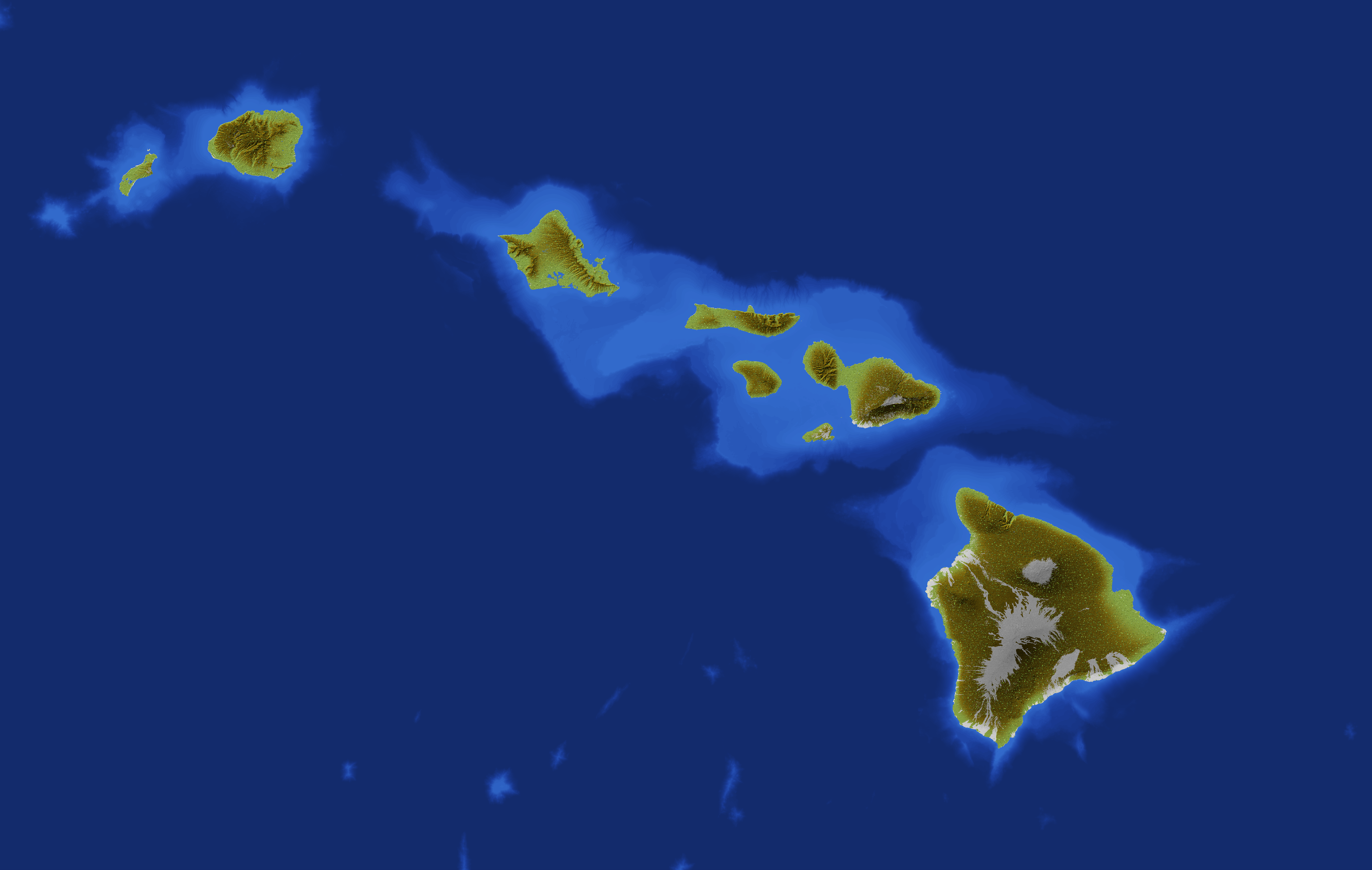
While most U.S. states feature at least some straight-line borders drawn by surveyors and politicians, Hawaii stands alone with completely natural, curved borders defined entirely by its coastlines.
When looking at a map of the United States, you'll notice that most state borders feature at least some straight lines-geometric boundaries drawn by surveyors and politicians rather than nature. However, among all 50 states, Hawaii stands completely unique as the only state without a single straight-line border. This geographical distinction reflects Hawaii's natural formation and isolated position in the Pacific Ocean.
Hawaii's borders are defined entirely by its coastlines, creating a completely irregular boundary that follows the natural contours of its volcanic islands. This distinctive characteristic separates Hawaii from the mainland states and tells a story about both its physical geography and political history.
Why Hawaii Has No Straight Borders
Hawaii's borders are determined exclusively by where land meets ocean. As an archipelago consisting of 137 islands (though only 7 are typically inhabited), Hawaii's boundaries are entirely dictated by natural coastlines. Unlike mainland states whose borders were often drawn using latitude and longitude lines or other arbitrary measurements, Hawaii's borders were formed by volcanic activity and erosion over millions of years.
The state's water boundaries extend to 12 nautical miles offshore, as is standard for U.S. territorial waters. Even these maritime boundaries follow curved lines, as they maintain a consistent distance from the irregularly shaped coastlines.

Formation of Hawaiian Islands
The curved, irregular borders of Hawaii are a direct result of how the islands formed. The Hawaiian archipelago was created by a geological hotspot beneath the Pacific tectonic plate. As the plate moved over this stationary hotspot, a series of volcanoes emerged from the ocean floor, creating the island chain we know today.
The Hawaiian hotspot continues to be active, with ongoing volcanic activity at Kīlauea on the Big Island. This volcanic origin means that the islands' shapes-and therefore borders-are determined by lava flows, erosion, and subsidence rather than human-drawn boundaries. The islands range from the still-growing Big Island of Hawaii to the heavily eroded and much older Kauai, each with its own distinctive irregular shape.
Comparing Hawaii to Other States
Every other U.S. state has at least some portion of straight-line border. Even states with substantial natural boundaries like rivers or mountain ranges typically have some straight sections:
- Alaska, despite having mostly natural boundaries, has a straight-line border with Canada that follows the 141st meridian
- Michigan has many natural water boundaries but includes some straight-line segments
- Florida, though largely coastal, has straight-line portions of its northern border with Alabama and Georgia
Western states like Wyoming and Colorado are famous for their almost perfectly rectangular shapes created entirely from straight lines, representing the opposite extreme from Hawaii's all-natural boundaries.

Geographical Implications
Hawaii's lack of straight-line borders has several practical implications for the state:
First, boundary disputes are essentially nonexistent for Hawaii's land borders-a sharp contrast to many mainland states that have engaged in border disputes throughout American history. The ocean clearly defines where Hawaii begins and ends.
Second, the irregular coastlines create numerous bays, inlets, and natural harbors that have played crucial roles in Hawaii's development, from ancient Hawaiian settlements to modern shipping and naval operations at places like Pearl Harbor.
Third, the varied coastlines contribute to Hawaii's exceptional biodiversity, creating different microclimates and ecosystems within short distances. From the volcanic black sand beaches to protected coral reefs, these natural borders foster tremendous ecological variety.
Cultural and Political Significance
Hawaii's natural borders reflect its unique political history as well. Unlike most states, Hawaii was an independent kingdom before becoming a U.S. territory and eventually a state in 1959. The islands' natural boundaries helped define the Hawaiian Kingdom long before Western contact.
Native Hawaiian culture has deep connections to the land and sea boundaries of the islands. Traditional land divisions called ahupuaʻa typically ran from mountain ridges to the sea, following natural contours rather than straight lines. This system recognized the ecological relationships between upland forests, agricultural zones, and coastal areas.
Today, Hawaii's natural borders continue to influence its identity as a state physically separated from the mainland United States, contributing to its distinct cultural character and approach to governance. The state's isolation and well-defined natural boundaries have helped preserve aspects of native Hawaiian culture while also creating challenges in transportation, shipping, and connectivity with the mainland.
Frequently Asked Questions About Hawaii: The Only U.S. State Without a Straight Line Border
Why doesn't Hawaii have any straight-line borders?
Hawaii doesn't have straight-line borders because it's an archipelago formed by volcanic activity. Its borders are entirely defined by where land meets ocean, following the natural coastlines created by lava flows, erosion, and other geological processes. Unlike mainland states where borders were drawn by surveyors using maps, Hawaii's boundaries were formed by nature.
Do any other states have only natural borders?
No, Hawaii is the only U.S. state with exclusively natural borders. All other states have at least some portion of straight-line border. Even states with significant natural boundaries like Michigan (Great Lakes) or Maine (coastline) have some straight segments where they border other states or countries.
How were Hawaii's borders officially established?
Hawaii's borders were officially established when it became a state in 1959, incorporating all the islands of the former Territory of Hawaii. These borders follow the natural coastlines of all 137 islands in the archipelago, extending to 12 nautical miles offshore as territorial waters.
Are Hawaii's borders changing over time?
Yes, Hawaii's borders do change slightly over time due to natural processes. Volcanic activity continues to add land on the Big Island, while erosion and sea level rise gradually alter coastlines on other islands. The most dramatic recent example was the 2018 Kīlauea eruption, which added new land to the Big Island's coastline.
What's the closest U.S. state to Hawaii?
Alaska is technically the closest U.S. state to Hawaii, with Aleutian Islands coming within about 2,000 miles of the Hawaiian Islands. California is the closest mainland state, approximately 2,390 miles from Hawaii.


