Four Corners is the only place in the United States where four states-Arizona, Colorado, New Mexico, and Utah-meet at a single point. This unique geographical intersection has a fascinating history tied to westward expansion, surveying challenges, and political decisions that created this one-of-a-kind landmark.
In the dusty desert landscape of the American Southwest lies a unique geographical oddity-the only place in the United States where four states meet at a single point. This quadripoint, known as Four Corners, brings together Arizona, Colorado, New Mexico, and Utah in a perpendicular intersection that draws visitors from around the world. But why do these four states meet at this precise location? The answer reveals a fascinating story of American expansion, surveying challenges, and political boundaries.
While state borders across America typically follow natural features like rivers or mountain ranges, Four Corners stands as a testament to human-drawn boundaries and the grid system that shaped much of America's western territories. The creation of this precise intersection wasn't an accident but the result of specific historical circumstances and political decisions.
Historical Origins of Four Corners
The story of Four Corners begins with the Treaty of Guadalupe Hidalgo in 1848, which ended the Mexican-American War and transferred a vast territory from Mexico to the United States. This newly acquired land needed organization, leading to the establishment of various territories that would eventually become states.
In 1861, Congress created the Colorado Territory with straight-line boundaries, including the 37th parallel north as its southern border. In 1863, the Arizona Territory was carved out of the New Mexico Territory, with the boundary set at the 109°03′ west longitude. These two boundary lines-one latitude, one longitude-created the conditions for a four-way intersection.

When Utah was established earlier as a territory in 1850, its eastern boundary was set at that same longitude line (109°03′ west), while New Mexico's northern boundary followed the 37th parallel. This perfect storm of perpendicular boundary lines created the conditions for the unique quadripoint we know today.
Surveying Challenges and Controversies
Establishing the Four Corners point wasn't as simple as drawing lines on a map. In the 1860s, surveyor Ehud Darling was tasked with marking the border between Colorado and New Mexico along the 37th parallel. In 1875, another surveyor named Chandler Robbins established the monument that marks the intersection of the four states.
However, modern measurements have sparked controversy about the monument's exact placement. Using GPS technology, some have claimed that the actual intersection point is about 1,800 feet east of the current monument. This discrepancy stems from the limitations of 19th-century surveying equipment and techniques.

Despite these claims, the U.S. Supreme Court has ruled that the monument's location is legally binding, regardless of any surveying errors. The principle of "monument over measurement" prevails in boundary law, meaning the physical markers take precedence over later measurements.
Political Decisions That Created Four Corners
The creation of Four Corners wasn't inevitable-it resulted from specific political decisions about how to organize the western territories. Congress could have chosen natural landmarks as boundaries, as was common in eastern states, but instead opted for straight-line boundaries based on latitude and longitude.
This decision reflected the influence of the Jefferson grid system, which favored orderly, rectangular land divisions over irregular boundaries following topographical features. The grid system made land surveys, sales, and administration more straightforward in the rapidly expanding nation.
Additionally, the timing of statehood for these four regions played a crucial role. Colorado became a state in 1876, Utah in 1896, and both New Mexico and Arizona in 1912. As these territories transitioned to statehood, they maintained their established boundaries, preserving the quadripoint.
The Four Corners Monument Today
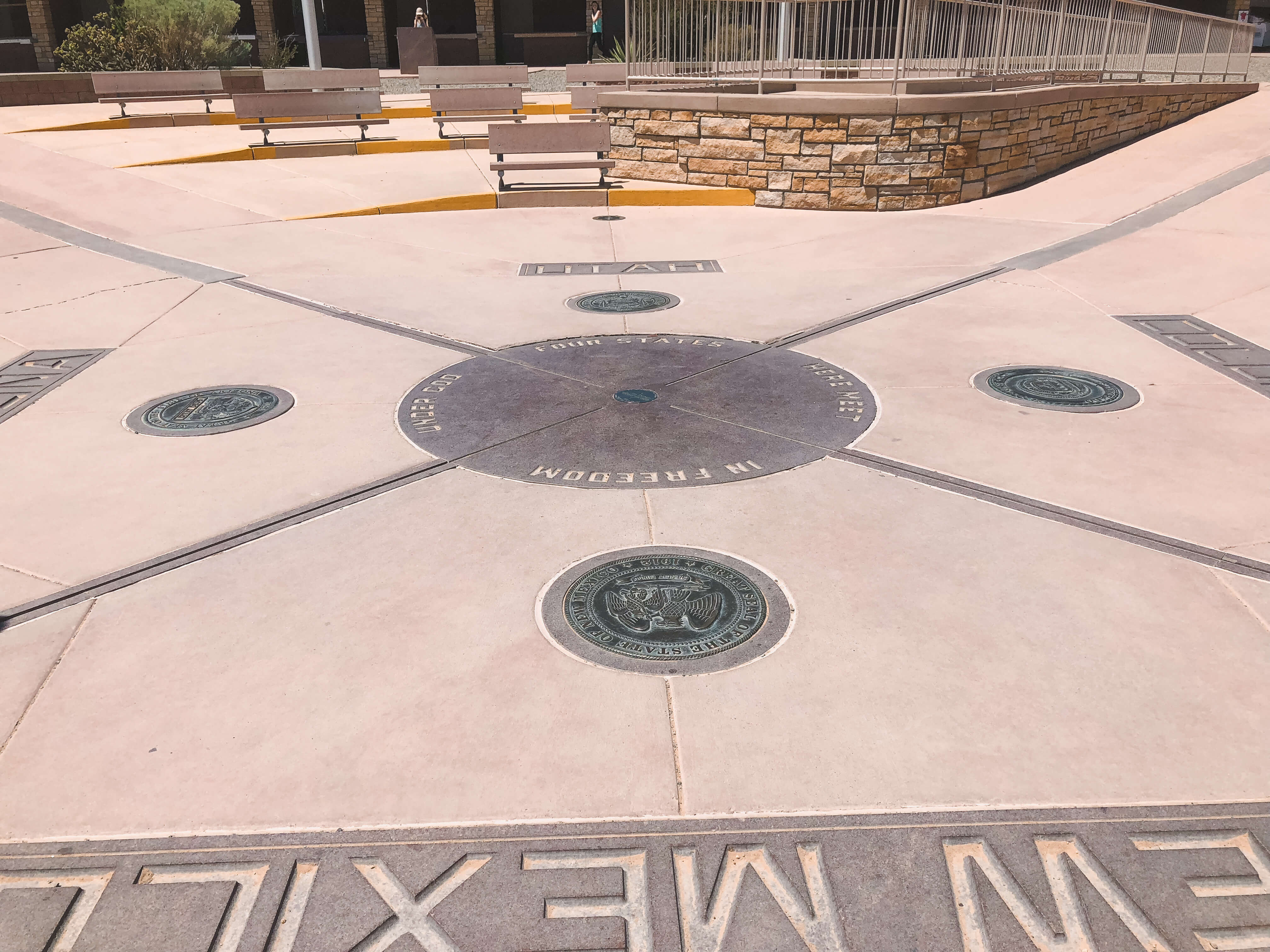
Today, visitors can find the Four Corners Monument on Navajo Nation land, managed jointly by the Navajo and Ute Mountain Ute tribes. The current monument features a granite and brass disk marking the intersection point, surrounded by the state seals and flags of the four states.

The site has become a popular tourist destination, with visitors often posing for photos with their limbs stretched into all four states simultaneously. Around the monument, vendors (primarily Navajo and Ute) sell Native American crafts, jewelry, and food, creating a cultural marketplace.
In 2010, the monument underwent a $1.5 million renovation, which expanded the plaza, added interpretive signs, and improved visitor facilities. Despite its remote location, approximately 250,000 visitors make the journey to this unique geographical point each year.
Cultural Significance to Native Americans
While Four Corners represents state boundaries drawn by the U.S. government, the area holds deeper significance for the indigenous peoples who have inhabited the region for centuries. The monument sits on Navajo Nation land, but the area has historical connections to several tribes including the Ute, Hopi, and Zuni.
For many Native Americans, these imposed state boundaries are relatively meaningless compared to their traditional territorial understandings. The region around Four Corners contains numerous sacred sites and has been home to indigenous peoples since long before European colonization.

Today, the management of the monument by the Navajo Nation represents an important aspect of tribal sovereignty. The revenue generated from entrance fees and vendor permits helps support the local Native American communities, turning a symbol of American territorial expansion into a source of economic opportunity.
The Visitor Experience
Visiting Four Corners offers more than just the novelty of standing in four states at once. The surrounding region, known as the Four Corners region, offers spectacular landscapes including Mesa Verde National Park, Monument Valley, and Canyon de Chelly.
The monument itself is relatively simple, located in a remote desert location that requires determination to reach. There are no major cities nearby-Cortez, Colorado and Farmington, New Mexico are the closest towns of any size. The isolated nature of the site contributes to its unique atmosphere.
Visitors should be prepared for desert conditions, with hot summers and cold winters. The monument is typically open year-round, though hours vary seasonally. The entrance fee (around $8 per person) goes to the Navajo Nation, which maintains the site and facilities.
While the monument may seem like a simple tourist photo opportunity, it represents the intersection of American history, geography, politics, and indigenous cultures-a physical manifestation of the complex forces that shaped the American West.
Frequently Asked Questions About Why Four States Meet at Four Corners: The Fascinating Story Behind America's Unique Intersection
Is Four Corners the only place in the US where four states meet?
Yes, Four Corners is the only place in the United States where four states (Arizona, Colorado, New Mexico, and Utah) meet at a single point. There are no other quadripoints among U.S. states, making this geographical feature truly unique.
Is the Four Corners Monument in the exact right spot?
While modern GPS measurements suggest the monument may be about 1,800 feet off from the actual intersection point, legally it doesn't matter. The U.S. Supreme Court has upheld the principle of "monument over measurement," meaning the physical marker establishes the legal boundary regardless of any surveying errors.
Who owns the Four Corners Monument?
The Four Corners Monument is located on Navajo Nation land and is managed by the Navajo Nation Parks and Recreation Department. The entrance fees and vendor permit revenues benefit the Navajo Nation and local communities.
What's the best time of year to visit Four Corners?
Spring (April-May) and fall (September-October) offer the most comfortable temperatures for visiting. Summer months can be extremely hot with temperatures exceeding 100°F, while winter can bring cold temperatures and occasional snow. The monument typically has reduced hours during winter months.
Are there facilities at the Four Corners Monument?
Basic facilities include restrooms, picnic tables, and vendor booths selling Native American crafts, jewelry, and food. There are no lodging or dining establishments at the monument itself, so visitors should come prepared with water and supplies.
Why were straight lines used for these state boundaries instead of natural features?
Straight-line boundaries were chosen as part of the Jefferson grid system, which favored orderly, rectangular land divisions that made surveying, selling, and administering land more straightforward during America's westward expansion. Unlike the eastern states, which were established earlier and often used rivers or mountain ranges as boundaries, these western territories were divided using latitude and longitude lines.


