America's network of scenic highways offers some of the most spectacular driving experiences in the world. From the rugged Pacific coastline to the majestic Appalachian Mountains, these routes showcase the stunning diversity of America's natural landscape, providing unforgettable journeys for road trip enthusiasts.
America's vast and varied landscapes are perfectly showcased through its network of scenic highways that wind through mountains, hug coastlines, and traverse breathtaking wilderness. These iconic routes aren't just about getting from point A to point B-they're about the journey itself, offering drivers and passengers alike unforgettable vistas and experiences that capture the essence of America's natural beauty.
From ancient forests to desert plateaus, from tropical paradise to arctic tundra, these spectacular driving routes represent some of the most awe-inspiring road trips anywhere in the world. Pack your camera, prepare your playlist, and get ready to explore the most scenic highways that the United States has to offer.
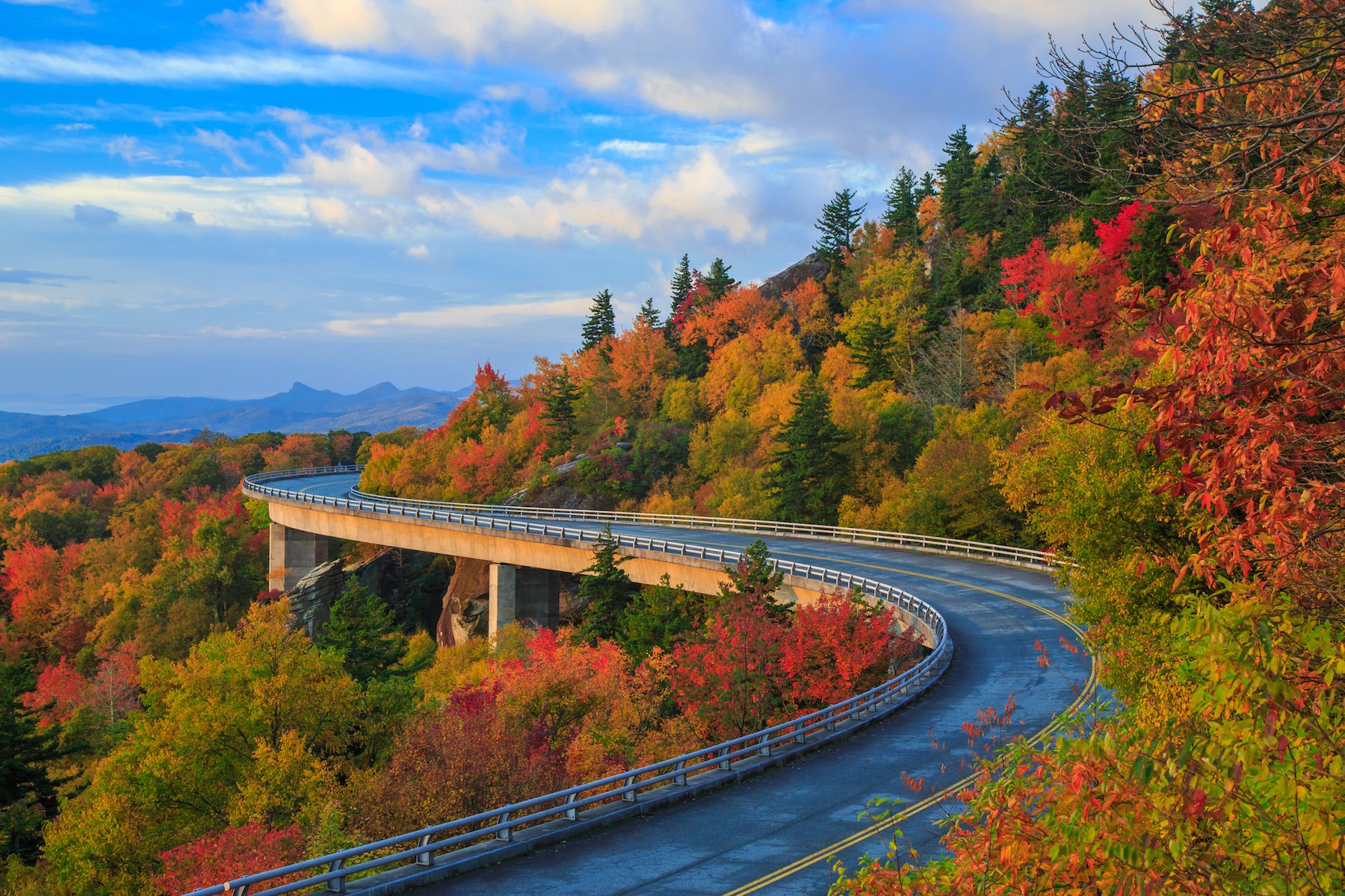
Blue Ridge Parkway
Winding for 469 miles through Virginia and North Carolina, the Blue Ridge Parkway is often called "America's Favorite Drive." This remarkable route connects Shenandoah National Park to the Great Smoky Mountains National Park, showcasing the breathtaking beauty of the Appalachian Highlands.
The parkway is especially spectacular during autumn when the forests erupt in a kaleidoscope of reds, oranges, and yellows. With a speed limit of just 45 mph, the road encourages a leisurely pace perfect for soaking in the panoramic mountain views, exploring hiking trails, and discovering the rich cultural heritage of the Appalachian region.

Don't miss stops like Mabry Mill, Linn Cove Viaduct, and the numerous overlooks offering breathtaking vistas of the ancient mountains and valleys that define this region.
Pacific Coast Highway
California's Pacific Coast Highway (Highway 1) stretches along much of the state's rugged coastline, offering what many consider the ultimate coastal drive in America. The most dramatic section runs for 123 miles between Monterey and Morro Bay, including the world-famous Big Sur region.
Hugging steep cliffs above crashing waves, this engineering marvel provides unobstructed views of the Pacific Ocean meeting jagged shorelines. The route passes through charming coastal towns, redwood forests, and across iconic structures like the Bixby Creek Bridge-a favorite for photographers.

Plan your drive for clear weather to fully appreciate the dramatic coastal scenery, and leave plenty of time for stops at overlooks, beaches, and state parks along the way.
Going-to-the-Sun Road
Cutting through the heart of Glacier National Park in Montana, the Going-to-the-Sun Road is a 50-mile engineering masterpiece that crosses the Continental Divide at Logan Pass (elevation 6,646 feet). This narrow, winding mountain road offers some of the most spectacular alpine scenery in North America.
Open only during summer months due to heavy snowfall, this road provides access to glacial lakes, cedar forests, and alpine meadows bursting with wildflowers. Wildlife sightings are common, with opportunities to spot mountain goats, bighorn sheep, and even bears.

The road's western portion passes through lush temperate rainforest, while the eastern side offers dramatic views of the stark mountain front where the Rockies meet the Great Plains-providing a study in contrasts along a single route.
Overseas Highway
The Overseas Highway (U.S. Route 1) from Miami to Key West is one of America's most unique driving experiences, spanning 113 miles across a chain of islands connected by 42 bridges. The most impressive of these is the Seven Mile Bridge, which stretches across open water offering panoramic views of the Gulf of Mexico on one side and the Atlantic Ocean on the other.
This tropical route provides a truly unique driving experience where you're surrounded by turquoise waters for much of the journey. The highway island-hops through the Florida Keys, each with its own distinct character, from Key Largo with its coral reef to quirky Key West with its sunset celebrations.

Stop along the way for snorkeling, fishing, or sampling key lime pie at roadside stands, and keep your eyes peeled for wildlife both in the water and at preserves along the route.
Historic Route 66
Though no longer an official U.S. highway, Route 66 remains America's most famous road. Stretching over 2,400 miles from Chicago to Santa Monica, this historic route represents the ultimate American road trip, taking travelers through the heart of the country across eight states.
The route passes through an incredible variety of landscapes from the Great Plains to the Mojave Desert, with plenty of quirky roadside attractions along the way. Vintage neon signs, classic diners, and unusual landmarks like the Cadillac Ranch in Texas make this journey as much about American culture as it is about scenic beauty.

While the entire route would take weeks to explore properly, even short sections offer a nostalgic glimpse into America's golden age of automobile travel, particularly in well-preserved segments in Arizona and New Mexico.
Beartooth Highway
The Beartooth Highway (U.S. Route 212) is a 68-mile stretch of road that crosses the Beartooth Mountains in Wyoming and Montana, reaching an impressive altitude of 10,947 feet at Beartooth Pass. Charles Kuralt famously called it "the most beautiful drive in America," and it's easy to see why.
This high-alpine highway offers access to pristine wilderness with dramatic switchbacks, spectacular vistas, and numerous alpine lakes. The road serves as the northeast entrance to Yellowstone National Park, making it a perfect scenic approach to America's first national park.

The highway is typically open only from late May through early October due to heavy snowfall. Even in summer, be prepared for rapidly changing weather conditions and dramatic temperature shifts as you climb through different ecological zones.
Road to Hana
Hawaii's Road to Hana (Highway 36 and 360) on the island of Maui is only 64 miles long, but with over 600 curves and 54 one-lane bridges, it's a driving adventure that typically takes all day to complete. This tropical route winds through lush rainforests, past towering waterfalls, and along dramatic coastal cliffs.
The journey showcases the unspoiled natural beauty of Maui's eastern coastline. The road itself is a marvel of engineering, carved into the side of a volcano and offering glimpses of black sand beaches, bamboo forests, and tropical fruit stands along the way.

While the town of Hana itself is the nominal destination, the journey truly is the reward. Take your time, stop frequently, and experience the many natural wonders along this quintessential Hawaiian adventure.
Million Dollar Highway
Part of the San Juan Skyway in southwestern Colorado, the Million Dollar Highway stretches for about 25 miles between Silverton and Ouray. Built in the late 1880s, this mountain passage is carved into the side of the San Juan Mountains with sheer drop-offs and few guardrails-creating both spectacular views and white-knuckle driving conditions.
The road traverses three high mountain passes and offers jaw-dropping views of the rugged San Juan range, with countless waterfalls, mining ruins, and colorful alpine meadows along the way. The route is particularly stunning during wildflower season in July and when fall colors peak in late September.

The name allegedly comes from an early traveler who said you couldn't pay him a million dollars to drive it again-though others claim it references the value of the precious ore in the roadbed or the cost of construction. Regardless, the views are certainly worth millions.
Natchez Trace Parkway
Following a historic travel corridor used by Native Americans and early European settlers, the Natchez Trace Parkway stretches 444 miles from Natchez, Mississippi, to Nashville, Tennessee. This scenic route is deliberately designed to be driven at a leisurely pace, with no commercial traffic allowed.
Unlike many western scenic byways, the Natchez Trace offers a more subtle beauty, winding through the rolling hills and farmland of the rural South. The route is known for its historical significance, with numerous archaeological sites, historic buildings, and interpretive exhibits along the way.

Highlights include the spectacular double-arch bridge near Franklin, Tennessee, numerous Native American mound sites, and access to sections of the original historic trace footpath. Spring and fall offer particularly scenic driving with dogwoods and redbuds or colorful foliage enhancing the experience.
Historic Columbia River Highway
America's first scenic highway, the Historic Columbia River Highway in Oregon follows the Columbia River Gorge for 75 miles between Troutdale and The Dalles. Constructed between 1913 and 1922, this pioneering roadway was designed specifically to showcase the spectacular scenery of the gorge.
The route features elegant stone guardrails, graceful curves, and incredible engineering designed to blend with the landscape rather than dominate it. The western section passes numerous spectacular waterfalls, including the 620-foot Multnomah Falls-one of the tallest year-round waterfalls in the United States.

Today, some sections have been converted to hiking and biking trails, while drivable portions offer access to viewpoints overlooking the massive gorge carved by ancient floods. The route provides a perfect contrast to the adjacent Interstate 84, showing how roads can be both functional and beautiful.
North Shore Scenic Drive
Minnesota's North Shore Scenic Drive (Highway 61) follows the shoreline of Lake Superior for 154 miles from Duluth to Grand Portage at the Canadian border. This Great Lakes coastal journey offers views of the world's largest freshwater lake against a backdrop of the ancient Sawtooth Mountains.
The route passes through charming lakeside towns, state parks, and historic sites, with countless opportunities to explore lighthouses, waterfalls, and rocky beaches. The lake itself appears like an inland sea, with waves crashing against rugged shorelines and vast horizons where water meets sky.

Don't miss the iconic Split Rock Lighthouse, Gooseberry Falls, and the chance to hike portions of the Superior Hiking Trail for spectacular views. The drive is beautiful year-round but especially dramatic during fall color season and winter when ice forms along the shore.
Trail Ridge Road
Traversing Rocky Mountain National Park in Colorado, Trail Ridge Road (U.S. Highway 34) is the highest continuous paved road in the United States, reaching an elevation of 12,183 feet above sea level. This 48-mile route connects the towns of Estes Park and Grand Lake, crossing the Continental Divide along the way.
Open only from late May through mid-October due to snow, this alpine highway spends 11 miles above the tree line in the fragile tundra ecosystem. The panoramic views extend for miles in all directions, encompassing snow-capped peaks, alpine meadows, and deep forested valleys.

Wildlife viewing opportunities abound, with elk, bighorn sheep, and marmots frequently spotted. Numerous pull-offs and interpretive displays allow visitors to safely experience the high-alpine environment while learning about the region's natural history.
Frequently Asked Questions About 12 Most Breathtaking Scenic Highways in the USA You Need to Drive
What is the longest scenic highway in the USA?
The longest official scenic highway in the USA is the Great River Road, which follows the Mississippi River for about 3,000 miles through 10 states from Minnesota to Louisiana. Among the highways featured in our list, Historic Route 66 is the longest at approximately 2,400 miles from Chicago to Santa Monica.
When is the best time to drive the Blue Ridge Parkway?
The best time to drive the Blue Ridge Parkway is during fall foliage season, typically mid-October in the higher elevations of North Carolina and late October in Virginia. Spring is also beautiful when wildflowers bloom (April-May). Summer offers lush green landscapes but can be foggy and more crowded, while winter may bring road closures due to ice and snow.
Are these scenic highways suitable for RVs and larger vehicles?
It depends on the highway. Routes like the Natchez Trace Parkway and Blue Ridge Parkway can accommodate RVs, though there may be length restrictions. However, roads like the Road to Hana, Million Dollar Highway, and portions of the Pacific Coast Highway present significant challenges for larger vehicles due to narrow lanes, tight turns, and steep grades. Always research vehicle restrictions and recommendations before planning your trip.
How long does it take to drive the Pacific Coast Highway?
The most scenic portion of the Pacific Coast Highway (Highway 1) from Monterey to Morro Bay is about 123 miles and would take around 5 hours of pure driving time. However, to truly appreciate the route, most travelers spend 1-2 full days, allowing for stops at viewpoints, beaches, and attractions. The entire Highway 1 from San Francisco to San Diego could be a week-long journey with proper stops.
Which scenic highways in the USA are open year-round?
Several scenic highways remain open year-round, including the Pacific Coast Highway, Natchez Trace Parkway, Overseas Highway, and most sections of Historic Route 66. Mountain routes like Going-to-the-Sun Road, Beartooth Highway, and Trail Ridge Road have seasonal closures due to snow, typically opening only from late May/June through September/October.
What's the most challenging scenic highway to drive in America?
The Million Dollar Highway in Colorado is often considered among the most challenging due to its narrow lanes, tight switchbacks, steep drop-offs, and minimal guardrails. The Road to Hana in Maui presents different challenges with its 600+ curves and 50+ one-lane bridges. Both require focused driving and are not recommended for those uncomfortable with mountain driving or those prone to motion sickness.


