The United States contains some of the most parched landscapes on Earth, where rainfall is measured in mere inches per year and drought-adapted life forms have evolved remarkable survival strategies. These arid regions showcase nature's resilience in extreme conditions.
The United States houses some of the world's most extreme desert environments, where rainfall is scarce and temperatures can soar to unbearable heights. These arid landscapes might seem inhospitable at first glance, but they contain remarkable biodiversity and geological wonders that have adapted to survive in the harshest conditions.
From the lowest point in North America to high desert plateaus, these extremely dry regions showcase nature's resilience and offer visitors otherworldly landscapes unlike anywhere else on the continent. Let's explore America's driest places, where annual rainfall often measures in mere inches.
Death Valley, California
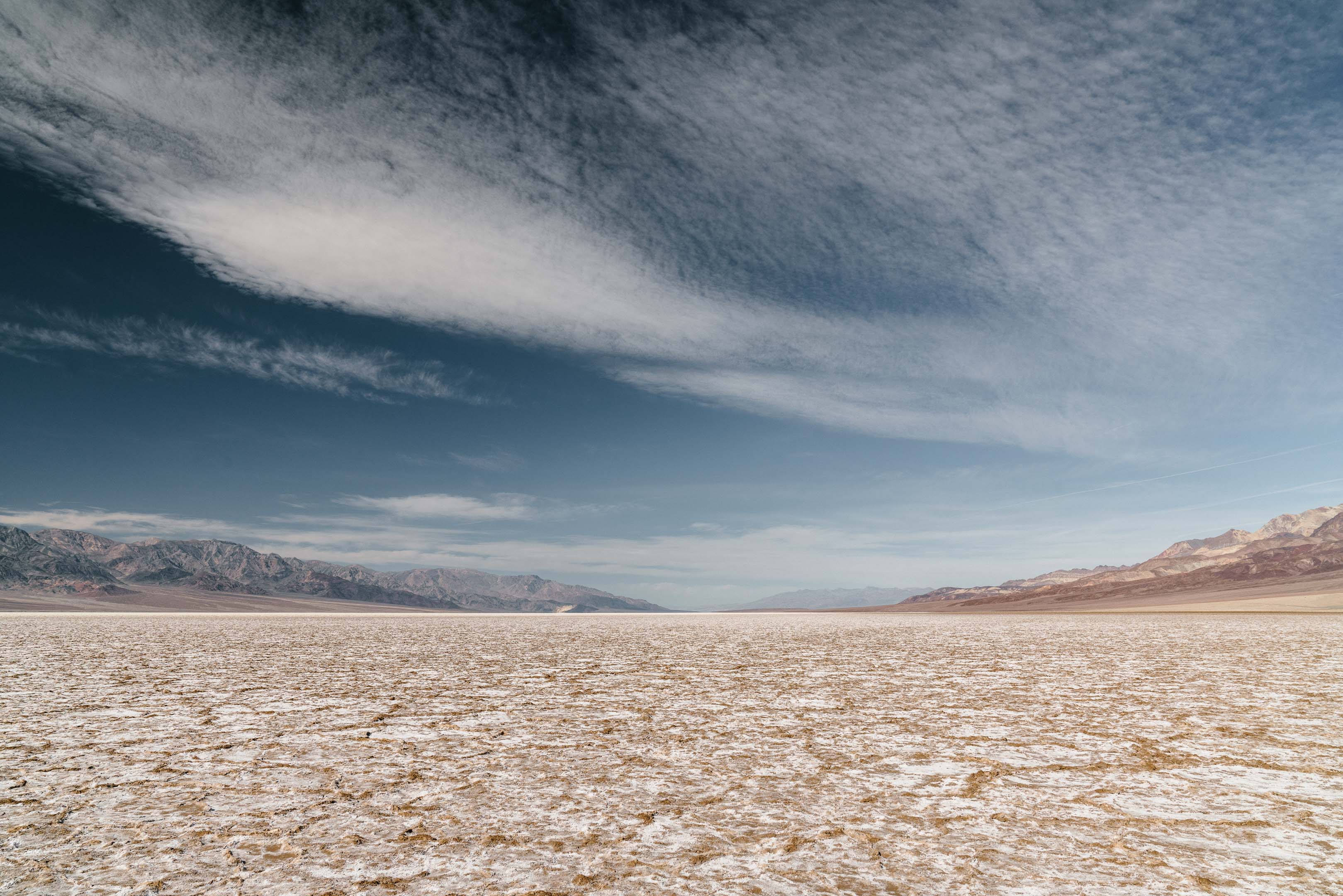
Holding the title of America's driest location, Death Valley receives an average of just 2.36 inches of rainfall annually. This forbidding landscape also holds the record for the highest temperature ever recorded on Earth at 134°F (56.7°C) in 1913.
Death Valley's Badwater Basin sits at 282 feet below sea level, making it the lowest point in North America. The extreme heat causes most moisture to evaporate before reaching the ground. Despite these harsh conditions, the park hosts over 1,000 plant species and numerous wildlife that have adapted to survive the extreme environment.

The park's dramatic landscape features salt flats, sand dunes, badlands, valleys, canyons, and mountains, creating a photographer's paradise, especially during sunrise and sunset when the colors transform dramatically.
Sonoran Desert, Arizona
The Sonoran Desert stands apart from other North American deserts because of its unique biseasonal rainfall pattern, receiving precipitation during both winter and summer monsoons. Despite this, annual rainfall averages only 3-15 inches.
This desert is famous for being the only place where the iconic saguaro cactus grows naturally. These majestic plants can grow up to 60 feet tall and live for 150-200 years, serving as crucial habitat for desert wildlife.
The Arizona-Sonora Desert Museum near Tucson offers visitors an excellent introduction to the desert's ecology. The region's biodiversity is surprising, with more than 2,000 plant species, 350 bird species, and numerous mammals, reptiles, and amphibians.
Mojave Desert
Spanning portions of California, Nevada, Utah, and Arizona, the Mojave Desert receives an average of 5 inches of rainfall annually. This high desert is characterized by its Joshua trees, which grow almost exclusively in this region.

The Mojave includes Joshua Tree National Park, Death Valley National Park, and the Mojave National Preserve. Its unique landscape features dramatic rock formations, vast bajadas (alluvial fans), and seasonal wildflower blooms that can be spectacular after rare rainfall events.
The desert experiences extreme temperature fluctuations, sometimes varying by 50°F between day and night. These conditions have led to specialized adaptations among native plants and animals, including nocturnal lifestyles for many creatures.
Great Basin Desert
As the largest desert in the United States, the Great Basin Desert spans much of Nevada and parts of Utah, Idaho, and Oregon. Unlike the hot deserts to the south, this is considered a "cold desert" due to its higher elevation and more northern latitude.
The region receives approximately 7-12 inches of precipitation annually, with much of it falling as snow during winter months. The Great Basin is characterized by its basin and range topography - alternating mountain ranges and flat valley floors.
Great Basin National Park in Nevada showcases this desert's diverse environments, from sagebrush valleys to ancient bristlecone pine forests and limestone caves. The desert's isolation has created habitat for numerous endemic species found nowhere else on Earth.
Owens Valley, California
Nestled between the Sierra Nevada and White Mountains in eastern California, Owens Valley is one of America's deepest valleys and among its driest locations. The region receives about 5-7 inches of rainfall annually, creating a stark rain shadow desert.
Owens Valley gained notoriety through California's water wars, when Los Angeles diverted its water in the early 20th century, essentially drying up Owens Lake and creating one of America's worst dust pollution problems. Today, the dry lakebed is the largest single source of PM10 dust pollution in the United States.
Despite its arid conditions, the valley supports riparian habitats along remaining waterways, providing crucial wildlife corridors. The Alabama Hills near Lone Pine offer dramatic rock formations that have been featured in numerous Western films.
Colorado Plateau
Covering parts of Utah, Colorado, New Mexico, and Arizona, the Colorado Plateau hosts some of America's most iconic desert landscapes. The region receives approximately 10 inches of precipitation annually, with some areas receiving significantly less.

The plateau is famous for its colorful sandstone formations, deep canyons, and vast expanses of slickrock. It encompasses numerous national parks and monuments including Grand Canyon, Zion, Bryce Canyon, Arches, and Canyonlands.
Water has been the primary sculptor of this landscape, creating dramatic features despite the region's overall aridity. The plateau's high elevation (averaging 5,000-11,000 feet) contributes to its distinctive ecology, which differs from the lower, hotter deserts to the south.
Imperial Valley, California
Located in southeastern California bordering Mexico, the Imperial Valley receives less than 3 inches of rainfall annually. Despite being one of America's driest regions, it has become an agricultural powerhouse through extensive irrigation from the Colorado River.
The transformation of this desert into farmland represents one of the most dramatic examples of human modification of an arid landscape. The valley produces over $1 billion worth of crops annually, supplying much of America's winter vegetables.
Nearby, the Salton Sea stands as a cautionary tale about water management. Created by an irrigation accident in 1905, this landlocked body of water has been slowly drying up, increasing in salinity, and creating significant environmental challenges.
Chihuahuan Desert, Texas
The Chihuahuan Desert extends into west Texas and southern New Mexico from its main range in Mexico. This desert receives approximately 6-10 inches of rainfall annually, with most precipitation arriving during summer monsoon season.
Big Bend National Park showcases the Chihuahuan Desert's biodiversity, with more species of birds, bats, and cacti than any other national park. The region's isolation has led to numerous endemic species that have evolved to survive its harsh conditions.
Unlike some American deserts dominated by creosote bush, the Chihuahuan Desert features more diverse plant communities, including various grasses, yuccas, and agaves. The desert's higher elevation (most areas are above 3,500 feet) contributes to its distinctive character.
Las Vegas, Nevada
Beyond its famous Strip, Las Vegas sits in one of America's driest metropolitan areas, receiving just 4.2 inches of rainfall annually. The city's existence in such an arid environment represents humanity's technological triumph over natural limitations-and its environmental consequences.
Las Vegas draws its water primarily from Lake Mead, which has faced historic low levels in recent years due to drought and increasing demand. The city has implemented progressive water conservation measures, including paying residents to remove grass lawns and replace them with desert landscaping.
Despite the casino fountains and golf courses, Las Vegas has become a leader in urban water conservation out of necessity. The surrounding Mojave Desert landscape offers spectacular recreational opportunities at places like Red Rock Canyon and Valley of Fire State Park.
Climate Change Impacts
America's driest regions face increasing challenges due to climate change. Scientists project that the Southwest will experience more severe and prolonged droughts in coming decades, potentially creating even more extreme conditions in already parched landscapes.
Rising temperatures increase evaporation rates and reduce snowpack in mountains that provide crucial water to desert regions. These changes are already stressing native plant and animal communities, with some species facing habitat loss or range shifts.
Water management challenges will continue to intensify as populations grow in western states while water resources become more constrained. However, these regions also offer enormous potential for solar energy development, potentially transforming America's driest places into centers for renewable energy production.
Frequently Asked Questions About 10 Extreme Desert Landscapes: America's Driest Places
What is the driest place in the United States?
Death Valley, California is the driest place in the United States with an average annual rainfall of just 2.36 inches. It also holds the record for the highest temperature ever recorded on Earth at 134°F (56.7°C) in 1913. Despite these extreme conditions, Death Valley National Park hosts surprising biodiversity with over 1,000 plant species.
What makes these desert regions so dry?
Several factors contribute to the extreme dryness of America's desert regions: 1) Rain shadow effect - mountain ranges block moisture-laden air from reaching inland areas; 2) High pressure systems that prevent storm formation; 3) Distance from major moisture sources like oceans; 4) Elevation and topography that affect precipitation patterns; 5) High temperatures that increase evaporation rates.
When is the best time to visit America's desert regions?
The optimal time to visit most American deserts is during spring (March-May) and fall (September-November) when temperatures are moderate. Winter can be pleasant in lower-elevation deserts like Death Valley and the Sonoran Desert, while summer months (June-August) often bring dangerous heat exceeding 110°F in many desert regions. Spring also brings the possibility of wildflower blooms if winter rainfall has been adequate.
How do plants and animals survive in such dry conditions?
Desert organisms have evolved remarkable adaptations: plants may have deep root systems, waxy coatings to prevent water loss, or CAM photosynthesis (opening stomata at night). Many desert animals are nocturnal to avoid heat, obtain water from their food rather than drinking, have specialized kidneys to conserve water, and may estivate (summer hibernation) during the hottest months. Some species, like the kangaroo rat, can survive without ever drinking water.
Are America's deserts getting drier due to climate change?
Yes, climate models indicate that the American Southwest is experiencing an intensification of drought conditions due to climate change. Rising temperatures increase evaporation rates and alter precipitation patterns. The region is currently in a "megadrought" - one of the driest periods in the past 1,200 years. Water resources like the Colorado River and Lake Mead are showing significant strain, with water levels reaching historic lows in recent years.


