In 1956, President Dwight D. Eisenhower signed legislation that would fundamentally reshape America. The Interstate Highway System became the largest public works project in human history, stretching across deserts, mountains, and cities to connect every corner of the nation. But this wasn't just about roads-it was about national defense, economic transformation, and the birth of modern America.
When President Dwight D. Eisenhower signed the Federal-Aid Highway Act of 1956, he set in motion the most ambitious infrastructure project in American history. The Interstate Highway System would eventually span 48,756 miles, connecting cities, towns, and states in ways previously unimaginable. This network transformed how Americans lived, worked, and traveled, creating the modern landscape of commerce and mobility we know today.
But the story of how these highways came to connect all 50 states is more complex than a simple coast-to-coast construction project. It involved military strategy, political negotiations, engineering marvels, and even special considerations for states that weren't part of the contiguous United States. Understanding this achievement requires looking at both the vision that sparked it and the remarkable execution that made it reality.
The Vision Behind the Interstates
Eisenhower's inspiration for the interstate system came from two distinct experiences. As a young Army officer in 1919, he participated in the Transcontinental Motor Convoy, a military expedition that took 62 days to travel from Washington, D.C. to San Francisco. The journey was plagued by terrible road conditions, broken bridges, and impassable routes that convinced him America needed better highways.

Decades later, during World War II, Eisenhower witnessed Germany's Autobahn system and recognized its military value. These high-speed, limited-access highways allowed for rapid troop movement and military logistics. When he became president, Eisenhower combined these experiences into a vision for a national highway network that would serve both civilian commerce and national defense.
The system was designed with specific military requirements in mind: one mile in every five had to be straight enough to serve as an airstrip in emergencies, and overpasses needed sufficient clearance for military equipment transport. This dual-purpose design became a cornerstone of the project's political support.
The 1956 Federal Aid Highway Act
The legislation that created the Interstate Highway System was revolutionary in its scope and funding mechanism. The Federal-Aid Highway Act authorized $25 billion (equivalent to over $280 billion today) for construction over a planned 10-year period-though the project would actually take 35 years to complete.
The funding came from a newly created Highway Trust Fund, fed by federal gasoline taxes, tire taxes, and other automotive-related fees. This meant that highway users essentially paid for the highways through a use tax system. The federal government would cover 90% of construction costs, with states responsible for the remaining 10%, creating a powerful incentive for state participation.
The numbering system was carefully designed for national consistency: even-numbered interstates run east-west (like I-10 and I-90), while odd-numbered routes run north-south (like I-5 and I-95). Lower numbers appear in the south and west, with numbers increasing as you move north and east. Three-digit interstates are auxiliary routes serving metropolitan areas.
Construction Challenges Across Diverse Terrain
Building highways across America's diverse geography presented extraordinary engineering challenges. In the Rocky Mountains, engineers had to blast through solid rock and construct elevated roadways along steep mountainsides. The Glenwood Canyon section of I-70 in Colorado, completed in 1992, required 40 bridges and viaducts in just 12 miles and cost over $490 million.

Desert construction posed different problems. In the Mojave Desert, extreme temperatures caused asphalt to become soft and unstable. Engineers developed new paving techniques and materials that could withstand temperature swings of over 100 degrees Fahrenheit. The I-10 crossing through the Sonoran Desert required careful grading to prevent sand accumulation and flash flood damage.
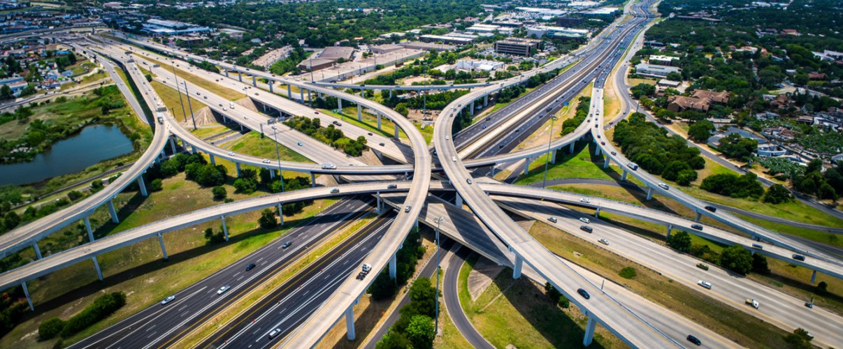
Urban construction proved even more controversial and complex. Building highways through established cities required massive land acquisition, demolition of neighborhoods, and displacement of residents. In some cities, like San Francisco, citizen opposition successfully stopped certain planned routes. The "freeway revolts" of the 1960s and 1970s led to cancellation or rerouting of numerous urban interstate segments.
Crossing major waterways demanded innovative solutions. The Chesapeake Bay Bridge-Tunnel on US-13 (which connects to the Interstate System) spans 17.6 miles and includes two mile-long tunnels to allow ship passage. The Lake Pontchartrain Causeway approaches in Louisiana required extensive bridge construction over wetlands and water.
Connecting the Lower 48 States
The contiguous 48 states were systematically connected through a network of primary and auxiliary interstate routes. The system's design ensured that no major city was far from an interstate connection, creating what planners called "national defense corridors" but what became the arteries of American commerce.
The first section of interstate highway opened was actually built before the 1956 Act-a portion of I-70 through Kansas in 1956. However, the systematic national construction accelerated rapidly afterward. By 1960, 10,000 miles were open to traffic. The pace continued through the 1960s and 1970s, with most major routes completed by 1980.

Some states were easier to connect than others. Flat, sparsely populated states like Kansas and Nebraska saw rapid progress, with long, straight highways built relatively inexpensively. Mountainous states like West Virginia and Colorado took much longer, with some segments not completed until the 1990s.
The system created major interstate hubs at cities like Atlanta, Chicago, and Dallas, where multiple routes converged. Atlanta, for instance, became known as the "crossroads of the South" where I-20, I-75, and I-85 intersect, contributing significantly to the city's economic growth and establishing it as a major logistics and distribution center.
Remote states presented unique challenges. Wyoming's I-80 crosses 400 miles of high desert and mountain terrain with severe winter weather. Special infrastructure including snow fences, wind warning systems, and designated "chain-up" areas were required to keep this critical transcontinental route operational year-round.
Alaska and Hawaii: Special Cases
The question of how the Interstate Highway System "connected" Alaska and Hawaii requires special explanation, as neither state has physical highway connections to the lower 48, and their interstate designations work differently.
Alaska has no roads officially designated as Interstate Highways, despite having received federal interstate construction funds. Instead, Alaska invested these funds in high-standard highways that meet interstate specifications but aren't part of the numbered system. The Alaska Highway, which does connect Alaska to Canada and the lower 48, was built as a military road in 1942 but isn't part of the Interstate System.
Alaska's highways that received interstate funding include portions of the Glenn Highway, Parks Highway, and other routes connecting Anchorage, Fairbanks, and other population centers. These roads were built to interstate standards with federal interstate funds but carry state route numbers instead.

Hawaii has three routes with Interstate designations-H-1, H-2, and H-3-despite being isolated in the Pacific Ocean. These highways, located on Oahu, were designated as interstates because they were built with 90% federal funding under the Interstate Highway System program and meet all interstate standards. The "H" prefix distinguishes them as Hawaii routes.
The justification for Hawaii's interstate designations was primarily military. Oahu hosts major military installations including Pearl Harbor, Hickam Air Force Base, and other defense facilities. The highways were deemed critical for national defense purposes, meeting the original Eisenhower vision of military utility even without physical connection to the mainland.
Economic and Social Transformation
The Interstate Highway System fundamentally restructured American society and economy. The ability to ship goods rapidly and reliably across the country revolutionized commerce. The "just-in-time" inventory system that dominates modern retail and manufacturing became possible only because of dependable interstate trucking.
The highways enabled suburbanization on an unprecedented scale. Workers could live farther from city centers and commute via highways, leading to explosive growth in suburban communities and shopping centers. Between 1950 and 1990, suburban populations grew by over 150%, directly correlated with interstate expansion.
Tourism transformed as automobile travel became easier and faster. National parks, beach resorts, and tourist destinations that were once difficult to reach became accessible to middle-class families. The highways created new industries: motel chains, fast-food restaurants, and gas station franchises that catered to highway travelers.

However, the system also had negative consequences. Urban neighborhoods, particularly minority communities, were often destroyed to make way for highways. The decline of passenger rail service accelerated as highways and automobiles became dominant. Small towns bypassed by interstates often experienced economic decline as traffic-and commerce-moved to highway exits and interchanges.
The environmental impact was significant. Increased automobile use contributed to air pollution, urban sprawl, and greater dependence on fossil fuels. The highways fragmented wildlife habitats and ecosystems, effects that continue to be addressed through wildlife crossings and environmental mitigation projects.
The Interstate System Today
The Interstate Highway System was officially "completed" in 1991 when the final section of I-70 through Glenwood Canyon, Colorado opened. However, the system continues to evolve with expansions, improvements, and redesignations. New interstate routes are still being added, particularly three-digit auxiliary routes serving growing metropolitan areas.
Today, the system carries about 25% of all vehicle traffic in the United States despite representing only 1.2% of total road mileage. This demonstrates the system's critical importance to American mobility and commerce. Over 70% of freight tonnage moves by truck, predominantly on interstate highways.
Maintenance and modernization present ongoing challenges. Much of the original infrastructure is now 50-70 years old and requires significant repair or replacement. The Highway Trust Fund faces chronic shortfalls as fuel efficiency improvements and electric vehicles reduce gas tax revenues while maintenance costs increase.

Recent additions to the system include the designation of I-69 through portions of Texas, Louisiana, Arkansas, Mississippi, Tennessee, Kentucky, and Indiana-a route still under construction in segments. Future interstate corridors are being planned to address emerging transportation needs and connect underserved regions.
The system faces 21st-century challenges including congestion in major metropolitan areas, aging infrastructure, and the need to accommodate autonomous vehicles and new transportation technologies. Despite these challenges, Eisenhower's Interstate Highway System remains one of the most successful infrastructure projects in history, fundamentally shaping American life for over six decades.


