Alaska is enormous, but most people don't realize just how big until they see it compared to familiar places. From swallowing entire countries to dwarfing the combined size of multiple U.S. states, Alaska's 665,400 square miles defies imagination. These visual comparisons reveal why mapmakers struggle to represent the Last Frontier accurately and why driving across it takes days, not hours.
When most Americans picture Alaska, they think of a state that's "somewhere up north" and "pretty big." But Alaska's true size is almost impossible to comprehend without direct comparisons. At 665,400 square miles, Alaska isn't just the largest U.S. state-it's larger than most people can imagine, dwarfing countries, continents' worth of territory, and challenging every assumption about American geography.
The problem is that standard maps dramatically shrink Alaska's appearance due to projection distortions. When you overlay Alaska onto the Lower 48 or compare it directly to countries and states, the results are genuinely shocking. These ten comparisons will forever change how you think about the Last Frontier's scale.

Alaska vs. The Continental United States
Here's the most dramatic comparison: you could fit Alaska over the eastern United States and it would stretch from Georgia to New York and from the Atlantic Ocean past the Mississippi River. If you place Alaska's outline over the Lower 48 with its easternmost point at the Atlantic coast, its western edge extends beyond the Dakotas.
To put exact numbers on it: Alaska comprises approximately 17.5% of the total U.S. land area. That means one state accounts for nearly one-fifth of America's entire territory. The continental United States (excluding Alaska and Hawaii) covers about 3.12 million square miles, making Alaska roughly one-fifth the size of all 48 contiguous states combined.
Another way to visualize this: if Alaska were split into two equal states, each half would still be larger than Texas, which brings us to our next comparison.
Alaska vs. Texas: The Real Size Champion
Texans famously pride themselves on their state's size, but Alaska is more than twice as large as Texas. While Texas covers 268,596 square miles, Alaska's 665,400 square miles means you could fit 2.47 Texas-sized states inside Alaska's borders.
In practical terms, this means that Alaska is bigger than Texas, California, and Montana combined. Even more impressive, you could fit Texas, Montana, and California inside Alaska and still have over 58,000 square miles left over-an area roughly the size of Georgia.

The distance from Alaska's northern coast to its southern panhandle (about 1,420 miles) is greater than the distance from the Canadian border to the Mexican border through Texas (about 1,260 miles). Alaska doesn't just beat Texas in area-it beats it in nearly every dimensional measurement.
Alaska vs. European Countries
Alaska's size becomes even more impressive when compared to European nations. Alaska is larger than Germany, France, Spain, and Italy combined. Individually, these countries measure: Germany (137,988 sq mi), France (247,368 sq mi), Spain (195,364 sq mi), and Italy (116,350 sq mi), totaling approximately 697,070 square miles-just slightly larger than Alaska alone.
More striking comparisons include:
- Alaska is nearly 5 times larger than England (50,301 sq mi)
- Alaska is 2.7 times larger than France, Europe's third-largest country
- Alaska is larger than Sweden, Norway, and Denmark combined
- You could fit 26 Irelands inside Alaska (Ireland is 27,133 sq mi)
If Alaska were a European country, it would be the largest in Europe by a massive margin, significantly bigger than the current record-holder, Ukraine (233,062 sq mi, excluding Crimea).
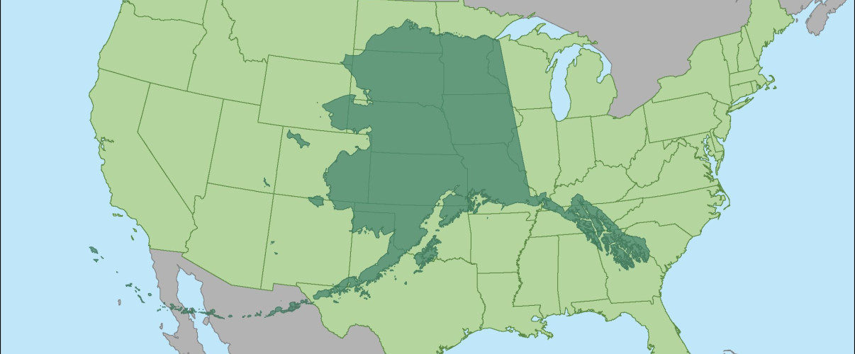
Alaska vs. Combined U.S. States
The sheer number of states that fit inside Alaska is staggering. Alaska is larger than the 22 smallest U.S. states combined. These states-from Rhode Island to South Carolina-together total approximately 652,000 square miles, just barely matching Alaska's footprint.
Some specific multi-state comparisons reveal Alaska's dominance:
- Alaska equals Texas + Montana + New Mexico (with room to spare)
- Alaska equals all of New England + New York + Pennsylvania + Ohio + Virginia
- Alaska equals California + Nevada + Arizona + Utah combined

Looking at the entire eastern seaboard: Alaska is larger than every state from Maine to Florida combined, if you include only the states directly on the Atlantic coast. This includes Maine, New Hampshire, Massachusetts, Rhode Island, Connecticut, New York, New Jersey, Delaware, Maryland, Virginia, North Carolina, South Carolina, Georgia, and Florida-14 states in total.
Alaska's Coastline: Longer Than All Other States Combined
Alaska's size isn't just about land area-its coastline measures 6,640 miles (general coastline) or an incredible 33,904 miles (tidal shoreline, including islands and inlets). To put this in perspective, the tidal shoreline of all other U.S. states combined is approximately 44,000 miles, meaning Alaska alone accounts for more than 40% of America's total coastline.
This is longer than:
- The entire coastline of Africa (18,950 miles)
- The circumference of Earth at the equator (24,901 miles) for the tidal measurement
- California's coastline (840 miles general, 3,427 miles tidal) by a factor of nearly 10
Alaska's coastline is so extensive because it includes thousands of islands, deep fjords, and complex inlet systems. The state has more than 100,000 glaciers and countless bays that create an extraordinarily intricate coastal geography.
Alaska vs. Japan
Alaska is 1.76 times larger than Japan, despite Japan's population of 125 million compared to Alaska's approximately 733,000 residents. Japan's total area is 377,975 square miles (including all four main islands and smaller territories), making Alaska significantly larger.
The population density difference is staggering: Japan has about 331 people per square mile, while Alaska has roughly 1.1 people per square mile. This makes Alaska one of the most sparsely populated regions in the developed world.
If Alaska had Japan's population density, it would be home to 220 million people-more than two-thirds of the current U.S. population. Instead, vast areas of Alaska remain completely uninhabited, with some regions hundreds of miles from the nearest road or settlement.
Driving Across Alaska vs. Cross-Country Trips
The famous Alaska Highway stretches 1,387 miles from Dawson Creek, British Columbia, to Delta Junction, Alaska. But to truly drive "across" Alaska from its southeastern panhandle to its western reaches would require traveling the Dalton Highway to Prudhoe Bay and other routes, totaling well over 2,000 miles.
Driving comparisons that illustrate Alaska's scale:
- Anchorage to Nome: approximately 539 miles as the crow flies, but there's no road connection-you'd need to fly or take a boat
- Ketchikan to Prudhoe Bay: over 2,000 miles if a direct route existed
- Juneau to Barrow (Utqiaġvik): approximately 1,500 miles as the crow flies, no road connection possible
For context, driving from New York City to Los Angeles is approximately 2,800 miles. Driving the length of Alaska, if roads existed, would be roughly 70% of a cross-country trip within a single state. In reality, many of Alaska's communities are only accessible by plane or boat, making its effective size even more daunting.
Alaska's National Parks Compared to Entire States
Alaska contains 8 national parks, and several are individually larger than entire U.S. states. Wrangell-St. Elias National Park, the largest in the system, covers 13.2 million acres (20,625 square miles)-larger than the states of New Hampshire, Vermont, Massachusetts, Rhode Island, Connecticut, Delaware, and Hawaii.
Other Alaska national parks size comparisons:
- Gates of the Arctic National Park (8.5 million acres): larger than Belgium
- Denali National Park (6 million acres): larger than New Hampshire
- Katmai National Park (4.1 million acres): larger than Connecticut
- Glacier Bay National Park (3.3 million acres): larger than Delaware and Rhode Island combined

Together, Alaska's national parks cover approximately 52 million acres, which is larger than the entire state of Kansas (52.5 million acres). This means Alaska has set aside wilderness areas larger than most states just for preservation and recreation.
Alaska vs. California
Alaska is 4.2 times larger than California, despite California being the third-largest U.S. state at 163,696 square miles. You could fit four Californias inside Alaska with thousands of square miles remaining.
Yet California's population of approximately 39 million is more than 53 times larger than Alaska's 733,000 residents. If Alaska had California's population density (about 250 people per square mile), it would be home to 166 million people-approximately half the current U.S. population.
Distance comparisons also highlight the difference:
- California's length (north to south): approximately 770 miles
- Alaska's length (east to west): approximately 2,400 miles
- California's width (east to west): approximately 250 miles
- Alaska's north-south span: approximately 1,420 miles
Alaska is so much larger that you could fit California, Oregon, and Washington-the entire West Coast-inside Alaska with room left over.
Why Maps Make Alaska Look Smaller
The main reason people underestimate Alaska's size is map projection distortion. The Mercator projection, commonly used for world maps and many U.S. maps, significantly distorts size at high latitudes. Because Alaska sits between 51° and 71° North latitude, it appears much smaller than it actually is on standard maps.
On typical U.S. maps, Alaska is often shown in an inset box, usually scaled down to fit neatly beside Hawaii. These inset maps frequently show Alaska at 50-70% of its true scale relative to the Lower 48, creating a false impression that Alaska is only slightly larger than Texas.

When Alaska is shown at its true scale and overlaid on the continental United States, it becomes immediately obvious that it's not just "the biggest state"-it's in an entirely different category. The Albers equal-area conic projection, often used for U.S. maps, provides a more accurate representation, but Alaska's true size still surprises most viewers.
Websites and tools that allow users to drag and overlay Alaska onto other regions have become popular precisely because seeing is believing. When you can manipulate Alaska's outline yourself and watch it swallow multiple states or countries, the abstract numbers become concrete reality.
Frequently Asked Questions About 10 Mind-Blowing Size Comparisons That Show How Big Alaska Really Is
How many times bigger is Alaska than Texas?
Alaska is 2.47 times larger than Texas. Alaska covers 665,400 square miles while Texas covers 268,596 square miles. You could fit two complete Texas-sized states inside Alaska with room left over for an area larger than West Virginia.
What countries is Alaska bigger than?
Alaska is bigger than France, Spain, Germany, Italy, Sweden, Norway, Poland, and many others. It's nearly five times larger than England and 2.7 times larger than France. Alaska is also 1.76 times larger than Japan and would be the largest country in Europe if it were located there.
How many U.S. states can fit inside Alaska?
You can fit the 22 smallest U.S. states inside Alaska, from Rhode Island through South Carolina. Alaska is also larger than all of New England, New York, Pennsylvania, Ohio, and Virginia combined. It equals the combined area of California, Nevada, Arizona, and Utah.
Why does Alaska look so small on maps?
Alaska appears smaller on most maps due to Mercator projection distortion, which shrinks areas near the poles. Alaska is also often shown in an inset box scaled down to 50-70% of its true size relative to other states. When shown at accurate scale, Alaska's massive size becomes immediately apparent.
How long does it take to drive across Alaska?
Driving from Anchorage to Fairbanks (358 miles) takes 6+ hours. The Alaska Highway from Canada to Delta Junction is 1,387 miles. However, many parts of Alaska have no road connections at all-you cannot drive to numerous communities including Juneau (the capital), which are accessible only by plane or boat.
Is Alaska's largest national park bigger than some states?
Yes, Wrangell-St. Elias National Park (20,625 square miles) is larger than New Hampshire, Vermont, Massachusetts, Rhode Island, Connecticut, Delaware, and Hawaii individually. Alaska's eight national parks combined cover more area than the entire state of Kansas.
What is Alaska's population density compared to other places?
Alaska has only 1.1 people per square mile, making it one of the least densely populated regions in the developed world. In comparison, Japan has 331 people per square mile. If Alaska had Japan's density, it would have 220 million people-more than two-thirds of the U.S. population.
How does Alaska's coastline compare to other states?
Alaska's tidal coastline measures 33,904 miles, which is more than 40% of the entire U.S. coastline. This is longer than the coastline of Africa and nearly 10 times longer than California's coastline. Alaska's complex geography of islands, fjords, and inlets creates this extraordinarily long shoreline.


