Maine holds a unique distinction in American geography as the only state that shares a border with just one other US state. This geographical curiosity has profoundly shaped Maine's development and character throughout history.
Among the 50 United States, Maine stands apart with a geographical distinction that makes it unique in the nation. It is the only U.S. state that borders just one other state - New Hampshire to its west. This geographical curiosity has influenced everything from Maine's history and culture to its economy and transportation networks.
While most states share their borders with multiple neighbors, Maine's relative isolation has helped forge its independent character and strong regional identity, giving it the nickname "The Pine Tree State" and contributing to its reputation as a place apart from the rest of New England.
Maine's Geographical Uniqueness
Maine's distinctive border situation comes from its position in the northeastern corner of the United States. To the east and south lies the Atlantic Ocean, featuring Maine's iconic 3,478 miles of tidal coastline when you include all its islands and inlets. To the north and northwest, Maine shares an international border with the Canadian provinces of Quebec and New Brunswick, stretching approximately 611 miles.
This leaves only the western border, where Maine connects to the rest of the United States through its single state neighbor, New Hampshire. The Maine-New Hampshire border runs approximately 160 miles from the Atlantic Ocean northward to the Canadian border.

The Maine-New Hampshire Border
The border between Maine and New Hampshire is defined largely by the Piscataqua River and its tributaries in the south, before continuing northward along a surveyed line. This border was established in the 1740s, though it wasn't without controversy at the time.
The Piscataqua River creates a natural boundary and serves as an important waterway, with the Portsmouth Harbor area shared between the two states. The Portsmouth Naval Shipyard, despite its name, is actually located in Kittery, Maine, just across the river from Portsmouth, New Hampshire.
Key border crossing points include:
- Kittery-Portsmouth (Interstate 95)
- South Berwick-Dover
- Fryeburg-Conway
Historical Context
Maine's unusual border situation is deeply rooted in its history. Originally part of Massachusetts, Maine became the 23rd state on March 15, 1820, as part of the Missouri Compromise. This political arrangement helped maintain the balance between free and slave states in the early republic.
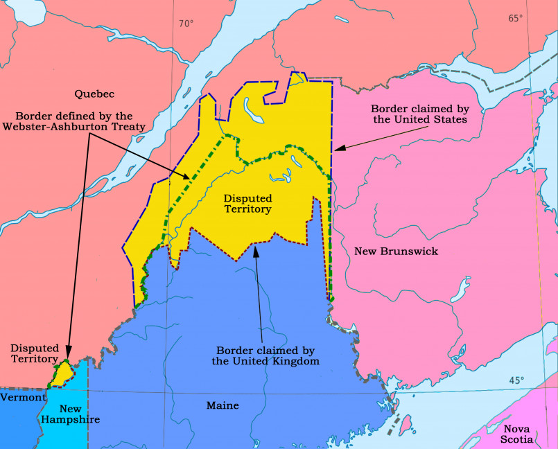
Prior to statehood, the area was contested territory, with both the British and Americans claiming portions of what would become Maine following the Revolutionary War. The final border with Canada wasn't fully resolved until the Webster-Ashburton Treaty of 1842, which settled disputed territory in what is now northern Maine.
The separation from Massachusetts and single-state connection to the rest of the U.S. helped foster Maine's independent identity and self-reliant culture from its earliest days as a state.
Impact on Culture and Identity
Maine's geographical position has significantly shaped its cultural identity. Often characterized as independent and self-reliant, Mainers have developed a distinct culture partially due to their relative isolation from the rest of the country.
This separation has helped preserve unique aspects of Maine culture, including:
- Distinctive New England accent and dialect variations
- Strong maritime traditions and seafaring heritage
- Rural values and connection to the outdoors
- A reputation for practicality and resourcefulness
The state motto, "Dirigo" (Latin for "I lead"), reflects this independent spirit that has developed in part due to Maine's unique geographical position.

Economic Implications
Having only one neighboring state has economic implications for Maine. Historically, this limited access created both challenges and opportunities:
Trade and Commerce: Most ground transportation and goods must pass through New Hampshire to reach the rest of the country, creating a natural gateway relationship. This makes southern Maine economically connected to the Greater Boston area.
Tourism: Maine's position as a destination requires most U.S. visitors to travel through New Hampshire, making tourism marketing strategies important. Approximately 37 million tourists visit Maine annually, with many driving through its single neighboring state.
International Trade: To compensate for limited state connections, Maine has developed strong trade relationships with its Canadian neighbors, with significant cross-border commerce, particularly in forestry products, agriculture, and manufacturing.
Transportation Connections
Maine's transportation infrastructure reflects its unique border situation. The primary connections to the rest of the United States include:
- Interstate 95 - The main highway artery connecting through New Hampshire
- Amtrak Downeaster - Train service from Boston through New Hampshire to Portland and Brunswick
- Portland International Jetport - Maine's largest airport, providing direct flights to major U.S. cities
- Ferry services - Connecting to Nova Scotia and various islands
This limited terrestrial connection has historically influenced development patterns, with population centers concentrated in the southern part of the state closer to New Hampshire and the rest of New England.
Comparison With Other States
While Maine is unique in having just one state neighbor, several other states have limited borders:
- Alaska - Borders no other U.S. states (connected only to Canada)
- Hawaii - Borders no other states (island state)
- Michigan - Peninsula state primarily bordered by Great Lakes, connecting only to Wisconsin, Indiana, and Ohio
- Florida - Borders only Georgia and Alabama
- Rhode Island - Borders only Connecticut and Massachusetts
However, Maine remains the only contiguous state with just a single state neighbor, making it a geographical anomaly in the United States. This distinctive feature continues to shape Maine's character and connections to the rest of America.
Frequently Asked Questions About Maine: The Only US State That Borders Just One Other State
Why is Maine the only state that borders just one other state?
Maine's position in the northeastern corner of the United States naturally limits its domestic borders. With the Atlantic Ocean to its east and south, and Canadian provinces (Quebec and New Brunswick) to its north and northwest, Maine is left with only its western border connecting to New Hampshire and the rest of the United States.
Has Maine always bordered only New Hampshire?
Yes, since Maine became a state in 1820. Prior to statehood, Maine was actually part of Massachusetts (known as the District of Maine). When it gained statehood as part of the Missouri Compromise, it maintained its single border with New Hampshire.
How long is the border between Maine and New Hampshire?
The Maine-New Hampshire border runs approximately 160 miles from the Atlantic Ocean northward to the Canadian border. The southern portion follows the Piscataqua River and its tributaries before continuing as a surveyed line.
How has having only one neighboring state affected Maine's economy?
Having just one neighboring state has created a gateway effect through New Hampshire for goods, services, and tourism. This has encouraged Maine to develop strong maritime trade, international connections with Canada, and self-sufficient industries. Tourism remains vital, with visitors necessarily passing through New Hampshire to reach Maine by land.
Are there any disputes over the Maine-New Hampshire border?
While the border was settled in the 1740s, there have been some minor modern disputes. The most notable concerned the ownership of Portsmouth Harbor and Seavey Island, where the Portsmouth Naval Shipyard is located. In 2001, the Supreme Court confirmed the island belongs to Maine, despite its name suggesting a New Hampshire location.
What states have the most neighboring states?
Tennessee and Missouri each border eight other states, making them the states with the most neighbors. Kentucky and Colorado each border seven states. This contrasts dramatically with Maine's single neighbor.


