Have you ever wondered why Wyoming is a perfect rectangle while Michigan looks like a mitten? Or why West Virginia has such an unusual shape? The story behind how American state boundaries were drawn is a fascinating tale of politics, geography, and sometimes pure chance.
Let's explore how these boundaries came to be and the fascinating stories behind them.

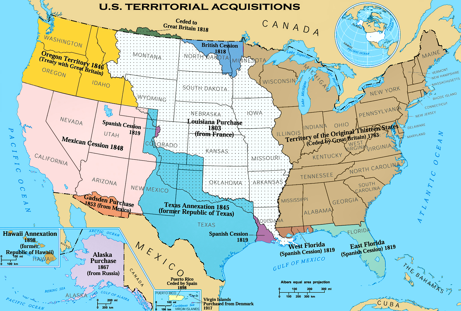
Colonial Boundaries
The original thirteen colonies' boundaries were largely determined by royal charters and grants, often with vague or conflicting descriptions. Delaware, Pennsylvania, New Jersey, Georgia, Connecticut, Massachusetts, Maryland, South Carolina, New Hampshire, Virginia, New York, North Carolina, and Rhode Island each had unique border stories.
For example, Pennsylvania's straight northern border at 42° latitude was carefully surveyed to resolve conflicts with New York, while its southern border with Maryland was established by the famous Mason-Dixon Line in the 1760s. Connecticut and Massachusetts both claimed wide strips of land stretching to the Pacific Ocean, leading to overlapping claims that would take decades to resolve.
Virginia, the largest colony, originally claimed vast territories northwest of the Ohio River. Many colonial borders followed natural features like the Delaware River between New Jersey and Pennsylvania, but some relied on astronomical observations and mathematical calculations. Rhode Island's boundaries were particularly contentious, with both Massachusetts and Connecticut disputing its borders well into the 18th century.
The Northwest Ordinance
The Northwest Ordinance of 1787 established a crucial precedent for creating new states from the territory north of the Ohio River and east of the Mississippi. It introduced the practice of using geometric boundaries - straight lines running along latitude and longitude - to define state borders. This system would later be applied across much of the western United States.
Under the ordinance, the Northwest Territory was eventually divided into five states: Ohio, Indiana, Illinois, Michigan, and Wisconsin (with part of Minnesota). The ordinance specified that states should be "rectangular in form," setting a precedent that would influence western state boundaries for the next century. It also established the Ohio River and the Great Lakes as natural boundaries for these new states.
This landmark legislation created a systematic approach to statehood, requiring new territories to meet specific population thresholds (60,000 free inhabitants) and establish proper governments before achieving statehood. The ordinance also prohibited slavery in these new territories, making the Ohio River a crucial boundary between free and slave states until the Civil War.
Natural Boundaries
Rivers form the most common natural state boundaries in America. The Mississippi River defines borders for Minnesota, Wisconsin, Iowa, Illinois, Missouri, Kentucky, Tennessee, Arkansas, and Louisiana. The Ohio River creates boundaries for Illinois, Indiana, Ohio, Kentucky, West Virginia, and Pennsylvania, while the Missouri River partially borders Nebraska, Iowa, Kansas, and Missouri.
Mountain ranges also serve as natural dividers. The Appalachian Mountains influence borders between Virginia, Kentucky, Tennessee, and North Carolina, while the Rocky Mountains help define Idaho's border with Montana and Wyoming. The Columbia River creates most of the boundary between Oregon and Washington.
However, using rivers as boundaries has created interesting challenges. Rivers can shift course over time through erosion and flooding, leading to disputes over which channel represents the true boundary. This has created unusual jurisdictional situations, such as the Kentucky Bend, where a small piece of Kentucky is completely surrounded by Missouri and Tennessee due to a dramatic bend in the Mississippi River.
Surveyor's Influence
The straight-line boundaries of western states were established by surveyors using sophisticated 19th-century tools like theodolites, astronomical compasses, and Gunter's chains. These geometric borders often follow lines of latitude and longitude, creating distinctive rectangular states like Wyoming (41°N to 45°N and 104°3'W to 111°3'W) and Colorado (37°N to 41°N and 102°3'W to 109°3'W).
Notable surveyors like Charles Mason and Jeremiah Dixon set high standards for accuracy, but technological limitations led to interesting quirks. The border between Utah and Nevada has a slight bend due to 19th-century surveying errors, while California's eastern border deviates from true north by several degrees. The Four Corners monument, where Arizona, Colorado, New Mexico, and Utah meet, was placed about 1,800 feet east of its legislatively specified location due to surveying limitations.
Modern GPS measurements have revealed numerous historical surveying discrepancies, but most of these "errors" have been legally formalized through subsequent legislation or Supreme Court decisions, preserving these quirks as part of America's geographical heritage. For example, South Dakota's western border with Wyoming follows a line that's slightly askew from true north, but it remains the official boundary.
Political Compromises
Many state boundaries were shaped by political compromises, particularly around the issue of slavery. The Missouri Compromise of 1820 established the 36°30' parallel as a dividing line between slave and free territories, influencing the borders of Missouri, Arkansas, Oklahoma, and Kansas. This compromise remained a crucial geographical division until the Kansas-Nebraska Act of 1854 overturned it.
The unusual shape of West Virginia resulted from its separation from Virginia during the Civil War, when 50 western counties loyal to the Union broke away in 1863. The Oklahoma Panhandle, originally called "No Man's Land," exists because Texas had to surrender territory north of 36°30' as part of its admission to the Union as a slave state. Similarly, Maine's 1820 separation from Massachusetts was part of the Missouri Compromise, maintaining the balance between free and slave states.
The Compromise of 1850 shaped several western territories, determining California's current boundaries and settling Texas's western border. This compromise also established New Mexico and Utah Territories, setting patterns for future state boundaries in the Southwest. The resulting borders reflected both geographical features and political calculations about maintaining power balance in Congress.
Border Disputes
Throughout American history, states have frequently disputed their boundaries, often leading to significant changes. The Toledo War of 1835-36 between Michigan and Ohio led to one of the most interesting compromises in boundary history: Michigan surrendered the Toledo Strip but received the mineral-rich Upper Peninsula as compensation, fundamentally altering its shape and future economic prospects.
Several historic disputes have shaped modern boundaries. Virginia and Maryland spent nearly 400 years arguing over the Potomac River boundary until a 2003 Supreme Court decision. The Missouri and Iowa border war of 1839 (the Honey War) erupted over confusion about which honey trees marked the true boundary. New Hampshire and Vermont battled over the Connecticut River boundary until the U.S. Supreme Court ruled in 1934 that the western bank was the border.
Modern boundary disputes continue to shape interstate relations. Georgia and Tennessee maintain an ongoing dispute over their border, which could give Georgia access to the water-rich Tennessee River—crucial for Atlanta's growing water needs. New Jersey and New York continue to debate jurisdiction over Ellis Island and Liberty Island, while South Carolina and Georgia occasionally dispute navigation rights on the Savannah River.